Tampilkan postingan dengan label city. Tampilkan semua postingan

Rabu, 27 April 2011

Royal Wedding - London is Dressing up

London is almost ready for the Royal Wedding later this week on the 29th of April. Preparations have been going on for weeks and the media is completely ull with details and stories covering the latest developments. Prince William is getting married to his long term partner Kate Middleton in a ceremony at Westminster Abbey. The event is expected to be the biggest of its kind ever and attract a world wide audience of some 2 billion viewers on TV, radio and internet. Copmared the wedding of Prince Charles and Princess Diana aracted a world wide audience of 750 million and the last Superbowl in America set the national audience record at 111 million viewers.

flags along Regent Street
Image taken from the hotmeganews / The flags along Regent Street in London transforming the space and time warping it back to the beginning of the last century.

Of course digital media is part of this these days and the official web page is central to this. However, the twitter feed will come from @clarencehouse. The general twitter tag for the occasion is #rw2011 or the #royalwedding. The official facebook page with 360'000 likes is also covering the events in detail.

Royal Wedding Route
Image taken from the the Sun / The plan of the route between Buckingham Palace and Westminster Abbey as chosen. Guests and the wedding couple will be traveling along it. Prince William and Kate Middleton will be traveling in the golden carriage if the weather is nice otherwise in a car.

The dressing up of the city as the venue is of course most obvious with the decoration that has been put of in the lead up to the Royal Wedding. Most notably are the coverage of British flags as shown above in Regent Street. It transforms the place completely and give a very different feeling from the usual Christmas decoration. The flag as such still has this official and important touch to it. It almost turns back the time to represent London one hundred or at least fifty years ago with a bit of steam and fog.

Then there is the change in security. It already is a big topic in London anyway but now police have stepped up and security has been tightened. The main focus is on the route between Buckingham Palace and Westminster Abbey of course, but also other major areas and attractions are being prepared.

Royal Wedding Security
Image taken from the toledoblade / Security is being checked and implemented across London.

There is a lot of money involved an additional guest in London and the UK in general are expected to help boost the economy.
The goverment is also very much involved with a lot of hopes to gain some benefit from the event directly. A number of oficial goverment web page feature the wedding as their current top priority. For example HNE on how to stay save during the Royal Wedding of course or DirectGov with the public service view on it.

With the day being declared an additional day off there is more time for employees to spend money. Merchandising is expected to make huge amounts by selling all the flags and cups and plates. The BBC says: "Restaurateurs and hoteliers can now look forwards to a two year bulge in tourism numbers, with the 2011 wedding to be followed by the 2012 Olympics." The UK Gift Company, which specialises in Royal items anticipates an upturn in business of about 30% to 40%.

Royal Wedding Seating Plan
Image taken from the BBC / Seating plan for the guest at Westminster Abbey. The structuring of the seating in groups is following clear ordering principles.

The seating is following a detailed ordering system of who is sitting where and next to whom. The arrangements have taken weeks of negotiation and preparations. 1900 guest will be seated. For everyone else there is an app for that, to take you round Westminster Abbey in 3D with a lot of background information. However, it will cost you a few bucks.

Royal Wedding Seating Plan
Image taken from the BBC / Layout of the cutlery on the table for Prince William and Kate's wedding reception.

Of course the planning of details goes further into details with small gestures and practices. From a city scale right down to how to dress for the wedding, how to greet and of course how to eat. The Royal Wedding has its very own layout of cutlery on the wedding reception table. The BBC has the details on how to manage all the different pieces. However, the BBC comments: "It's quite simple - start at the outside and work in as the meal progresses"

The guest list has only been released, but very much in the nature of the time has shortly after ben declared public data and the Guardian data blog features it, with the option to download the list as free data. Maybe you get a great viz out of it!


Visualisation using many eyes by IBM / Bubble chart using the open data of the Wedding invitation list, coloured by nationality. Click to interact.

The organisation of the wedding reflects the strong hierarchical organisation of the Royal concept. Both practically and socially, it is a clear structure of ranks with the Queen at the top end and this will be reinforced through practice on the day. Practice is feeding into al elements of the wedding, from invitation to seating, even to traveling, there is a very strict guide on who is leaving when for Westminster Abbey. Of course the most practical way is the addressing of people respecting the individual rank. The five levels after the Royals are: the Duke / Duchess, followed by the Marquess / Marchioness, followed by the Earl / Count or Countess, followed by Viscount / Viscountess, followed by Baron / Baroness, as described by Debretts.

There is a lot more to the Royal Wedding than just a couple getting married. It is not about the two individuals Prince William and Kate Middleton, but about the bigger idea of Royal and State. The event is a far reaching demonstration of a very old aristocratic practice and represents the position of England in general as part of the world.

This demonstration solely is based on practice, routines and established rites and in this case culminate in the wedding ceremony. This is the reason for the practice to be of such importance because only through its celebration it can be established and such an occasion is the perfect practice this structure can celebrate. The bigger idea is the hope that this wedding will put everything in to place.

This of course centres on the Royal family but reaches out from the palace to the wider London area, to national politics, to the society of this country and its related nations, to international politics and ultimately to the world. With this there are a lot of people and groups very keen on getting some positive benefit directly from this ceremony foremost probably the Prime Minister David Cameron and his Conservative Party as they are trying to deliver massive financial cuts and keep the people quite, but definitely other such as Boris Johnson for London and the upcoming Olympics 2012 and then of course the rehearsal of hierarchical structures will act as a boost to older traditions and society structures probably feeding into the Big Society idea the conservatives are trying to sell. It of course a big celebration of everything that has rank and name, but it pulls in the normal person too. Formost with the announcement of the Royal Wedding day to be a national bank holiday, an extra day off. With this you'll be buying a lot of good will. Of course then you also have the representatives and identification figurs featuring at the Royal Wedding, such as the Victoria and David Beckham, Joss Stone, Rowan Atkinson, Guy Ritchie or of course Sir Elton John.

These practices are employing symbols and simple seemingly elements such as flags all the way down Regent Street, but exactly this is what lets people create their identity and reinforces a practice of space and lets the Wedding become a great event.

Senin, 14 Maret 2011

Book - From City to House - Teaching Architecture

How to teach architecture? How to teach design and an understanding of context? Architecture is not something that happens isolated, architecture with it the building is always placed in the context of a fabric either rural or urban.

Architecture is different to other subjects in the sense that it involves a mistic combination of science, art and social components. The subject is widely regarded as a creative education, but on the other hand admired for technical skills as well as engineering knowledge. Furthermore, since most projects involved humans as users or inhabitants there are social aspects being pored into the mix. In short from the distance it looks very much interdisciplinary, a job for an al-rounder.

However, in recent years the profession has to some extend been dragged into an identity crisis, increasingly under pressure from different disciplines. After almost a century as the successful merge of scientist and artist, the architect has become a widely criticised and blamed professional. This has largely to do with changes in perception and values in the built environment and the increased pressure of sustainability issues. There has been a great deal of specialisation in many areas, technically and practically. A lot of specialists areas have managed to establish themselves within the domain of the building or the built environment. These are mainly related to the high degree of engineering in areas of structure, material, energy as well as manufacturing and management.

At the same time the image has shifted from the locally respected professional some architects have shot up to international stardom together with the concept of iconic architecture and buildings. In this bi-problematic context the question of architectural education is a dramatic one. How to teach architecture, how to lead a new generation of architects to find an identity and establish a sense of practice in a increasingly perceived as more and more complex context?

At the ETH's chair of architecture Dietmar Eberle this question has been extensively investigated and the reflection together with the planning for a new structure has lead to a publication "From the City to the House: a Design Theory" which was published by GTA Verlag. The book is published as a bilingual English - German publication.

He outlines the demands of architectural education as the ability to 'design on different levels, scales and in different disciplines simultaneously'. This builds on a "broad background of knowledge wich is distinguished by an interest in everyday life and experience". Eberle makes it very clear in his introduction that he does not see architecture as an art with the argument that acording to him " art lies claim to create a counter-world, the essential brief of architecture is to create useful worlds".

The didactics and method offered in architecture education at the Eberle Chair are founded on five key topics Place, Structure, Shell, Programm and Materiality. Also Eberle puts a lot of emphasis on the context, hence the book title, but the city as the context for the building leads through the book. Te didactic is linearly built to investigate on topic after the other as exercises, always combining the previous topics with the newly added on. This process ends with the ninth exercise that will combine all five topcis.

So far the introduction of the book, the really interesting and part worth looking into is the detailed documentation of the exercises using a mixture of student projects and essays. The wealth of ideas, test and concepts presented is amazing. Everything is very well presented and of course fits in exactly with the book structure. This creates a symbiosis very beneficial for the topic at hand. It is always good to have well documented case to present for making a point. And in this case this is definitely a striking argument.

After more than seven years of teaching at the ETH there is plenty of good material to showcase and it is a pleasure to not only scan but really to dive into the book and the many examples. A few of the indicated as illustrations with tis post.

However there are definitely more aspects to the teaching of architecture and there are other points to make. For examples as presented in another publication from the ETH from the Chair Angelil 'Cities of Change: Adis Abba' or the Harvard yearbooks and many more being published as communication from architecture school. Nevertheless this publication here is astonishingly consistent and complete and definitely a good starting point for the architect as a craftsman.

City to House
Image taken from ETH ARCH Chair Eberle / Book cover.

Eberle, D. & Simmendinger, P., 2010. Von der Stadt zum Haus. Eine Entwurfslehre
From City to House. A Design Theory
2nd ed., Zurich: GTA Verlag.

Rabu, 09 Februari 2011

Sorting Shapes and Cleaning up Cities

What would the world look like if we get everything sorted? Things would be tucked away neatly, places are clean, papers sorted and regulations clear. Maybe.

Sorting and cleaning, polishing and updating, pushing and flushing are frequent terms used in design and research and as part of the discussion definitely have a relevance. They convey a certain change and proposition together with implied 'to the better'.

Armelle Caron
Image taken from Armelle Caron / Paris as it is and sorted.

As usual with terms they can be overused, for things they don't apply or to describe something that is not this way or doesn't even exist. Even more so, they can be over stretched and filled with an missionary believe and practice and followism. This is definitely the case when people start to believe in one of the terms as being the only one, the world saving solution.

Academia is pruned to be a place for sorting and clearing, but on the other hand is also a very messy place. But hey invention and creativity are different beasts altogether. Anyway, it is probably the exchange and the collaboration that prevents ideas and concept to overflow and draining down one of these few juicy terms.

Armelle Caron
Image taken from Armelle Caron / Tamarac as it is and sorted.

Mapping is one of the very visual disciplines that is fundamentally about ordering and sorting. This is built on a intelectual concept of reference, singularity and ultimately truth. A very helpful strategy actually, with a lot of benefits as an abstract representation, simplified to clarify. Nevertheless, the combination of the terms is lethal in terms of reprojection. The things do no longer add up if the abstraction is reversed as a revitalised self. A map is a map, is a map, is a map.

For not bringing them back we can as well sort them pieces. In any order, as you please, but let them be abstractions.

Armelle Caron
Image taken from Armelle Caron / MontPellier as it is and sorted.

Armell Caron has produced these wonderfully sorted pieces of sections or urban plans, sorted into order, any order but the previous one. Nights working on the computer tracing and then moving piece by piece with the curser in Illustrator until neatly sorted in rows. Seems like a very meditative work, at least the power of them illustrations suggests this. Works developed 2005 / 2008.

Via PYTR 75, more details on Armell's blog, on socks-studio, urbain-trop-urabain, the map room or on deconcrete.

Armelle Caron
Image taken from urbain-trop-urabain / City blocks made from wood as a giant puzzle. Probably impossible to sort it exactly in the original way, but there are plenty of variations to mess about.

Rabu, 24 November 2010

Personalised Urban Space

If we start with Petra Kempf's publication 'You Are The City' we jump straight into the discussion about the personal expression in the urban environment. Clearly this has become dramatically individualised and
and citizens have grown into roles as independent user, aspiring for flexibility and uniqueness.
The technological development in the recent years, month actually, is fuelling these developments. Here individuality turns into solitary and disconnectednes with the latest app telling you whats happening around you. Interaction becoming the biggest thing as long as we don't need to talk to anyone.

The urban landscape is turning from a servicescape in to a stagescape for individuals to produce themselves as the latest celebrity. Interaction becomes one directional, the famous show off to be looked at, the ultimate aspiration.

The individualisation obviously is a very big topic in the media and some recent project are quite cleverly employing this trend to the point of questioning its real existence.

For example the current aviva campaign puts the individual in to the centre. On the website http://www.youarethebigpicture.com/ they started a collection of portraits, with the option to draw in your facebook image, as a representation of personal commitment and support. The great thing is the personalised video clip everyone gets as a sort of gift. The uploaded image is embedded in the clip and everyone has the chance to appears big in the city.


In fact aviva actually is running live projections of the submitted images in cities around the world. Some have ended, but on the page you have access to the recorded time lapse.

Another effort is made by the Dentsu London media company. They have recently had some really exciting project utilising the latest technologies with quite visionary content. See for example the iPad illumination clip.

THey were also looking into the personalisation of the city environment and visualised their ideas in two animated clip, sort of augmented visualisations. Their claim goes beyond the content, but this doesn't matter at the moment I guess.

The basic idea is to utilise and augment existing objects and surfaces with personalised content and information. The desire to keep up to date with the latest social networking news, updates, notifications and tweets. Some of the idea are quite interesting, especially the ones that aim at linking the individual back to the physical context. It is very simple, but for example the Dentsu train ticket idea is a different take on the location awareness trend.


There is a lot of potential in this trend to personalise the everyday environment. There might be individual benefit and surprises to be discovered for everyone. However it might be not as new as it would like to be. But it is certainly a new take on the everyday routines and a chance to embed it with the aspired independence and individuality of our current culture. Definitely the city is the playground.

Senin, 20 September 2010

Book - Urban Interventions, as the Space is Used

Urban spaces are public space, one presumes. Yes? Who owns the space and what does public actually mean in relation to oneself as an individua? How much authority is imposed on the route we travel daily?
In general public space is for everyone, but only in general. In detail this means it is for certain groups acting and behaving in a certain way. Excluding can take many forms and ranges from physical barriers, economical hurdles to social aspect.
The unwritten moral rules are formed in different layers and dependant on numerous factors. Often a temporal aspect is involved to make things more complicated. As a preliminary conclusion space and especially the ruling of is extremely complicated and often near impossible to interpret a the potential user.
However, maybe the question is not the right one, maybe it is not about the rules or regulations. Maybe it is about the agency of the user? What if te question were, what do you want to use it for, could it be used for this? To make a proposa instead of asking how, completely changes the dimension and the dialogue and unlocks a potentially very fruitful conversation between different groups of actors.

Gestalten
Image taken from regardsdusoir / Urban Interventions, 2010, Cover by Gestalten.

The dilemma goes back quite a bitin history and it could be argued that is in parts a child of the modernist city planning. The city is designed as a machine that runs and functions. Its main purpose is serving the residents and visitors, which in turn makes them user. However, the clear lines of the functional city and the meticulous designed links and connections have reached not far enough. The 'Junkspace' (Koolhaas, R., 2002. Junkspace. October, 100, 175-190.) produced in between is taking over and users can't cope with 'Junkspace', they are trained to function in transit only.

To navigate in the modern urban environment creativity is needed and especially action is needed. It has to be an proactive approach, no longer as users citizens have to commute, but a actors. Space is no longer what it looks like but it is what it's used for.

In an awesome new Gestalten publication 'Urban Interventions' the editors Robert Klanten and Matthias Huebner outline exactly how this 'acting' in urban spaces could look like. And from page one (actually page 8) an incredible 'tour d' urbanism' takes you on a journey through other peoples reinterpretation of space. The mere density and variety of the projects presented makes you wane stand up and go out there into the streets and have some fun. It is one of those reading experiences that creap into your mind and things are no longer what they used to be.

Harmen de Hoop
Image by Harmen de Hoop / Sandbox, Amsterdam, 1996. Paving stones removed with sand and toys added to create a child's play area.

The book is organised in seven thematic areas that are: Urban Canvas, Localized, Atachments, Public Privacy, Advertised and Natural Ways. Within this structure you can find gems such as Brad Downney's Spontaneous Sculptures - Broken Bike Lane, 2008 Berlin, Slinkachu's Little People, earlier blog post HERE, or Tazro Niscino's temporary rooms usually featuring a public sculture as for example in 'Engel', Basel, 2002.
Other works are more practical like Harmen de Hoop's public space add ons that quip spaces with additional functionality. Similarly practical or transformative is Oliver Bishop-Young's 'Skip Conversions: London, 2008.

One of my favourites is the 'Urban Camouflage' reinterpreting the dimensions of activity in the (public)spaces of hardware stores.

Urban Camouflage
Image by Urban Camouflage / 'Lappen', performed in Stockholm in 2007 /


The book actually doesn't provide the reader with the normally introductive 'rules of the book' and the table of content. Also each project is documented only with the basic project information, but not with any sort of interpretation. Very much in the sense of the introduction it is an explorative approach and how one reads the book is up to each individual. You can read it from front to back though if you desire.

A must read for every urbanist! Go out and have fun, you are the city.


Klanten, R., 2010. Urban Interventions: Personal Projects in Public Places, Die Gestalten Verlag.

Selasa, 14 September 2010

Seattle Tilt Shift

"I'd like to be under the sea in an octopus's garden in the shade ..." Actually this great timeLapse has neither to do with the sea nor with an octopus, but the music used with it is great. This line of text and the tune might follow you through the day though, so be careful.
However, the clip gives you a peep preview of Seattle and as one of the comments on the Vimeo page in respons to the clip goes: "This has that real Seattle light to it..."
I especially like the sequence with the two boats and the pier rocking in the waves, probably only visible in the timeLapse replay.

Senin, 13 September 2010

Book - Hong Kong's Rooftop Villages.

A city is built in many layers. Layers in the temporal sense, but also in layers in the physical sense. The two often go hand in hand. A new area brings a new layer, a new style develops a new typology or new technology allows for a change in usage.

In addition to time more factor can influence the type and number of layers. With more and more people living in cities, the density and pressure in certain areas can be one such factor. Unplanned or ilegal settlements can form spontaneously at different fringe locations. However even in innercity locations, if there is room.

In dense inner city locations however, very seldom one finds an unused spot, at least not on street level, but maybe on roof tops.

portraitsFabove03
Image by Wu/Canham taken from "portrait fro Above' / A view onto a rooftop village from across the road. The building dates from 1958 and is a Cantonese-style shophouse.

A new Peperoni Books publication with the title 'Portraits from Above: Hong Kong's Informal Rooftop Communities' by Rufina Wu and Stefan Canham portraits and documents a series of roof top communities in Hong Kong. The authors work with photographs, drawings and personal stories to tell the story of little villages that exist in the density of an urban mega city, hidden away in the sky.

At least they used to be far away from the streets, hidden on the flat roof of a fifties building, plugging into its infrastructure. Nowadays high rise buildings overshadow these roof tops by far and investment and land speculation threatens there base layer, the original building.

portraitsFabove02
Image by Wu/Canham taken from "portrait fro Above' / A view onto a rooftop village from across the road. Six staircases provide access to this 8 story building that hosts another three stories on the roof.

Wu and Canham provide insight into a very personal documentation of these villages. Very soon it becomes cear that these are actually a lot more than just slums. These houses or units are tiny and improvised, not in very good condition, uncomfortable, but they are homes. Almost all of them are carefully decorated and organised, as far as this is possible.

The documentation uses the three different methods, drawing, photographs and textual description, very cleverly and manages to put together a good, at times almost too clean, picture of these small communities. Each technique can develop its very own angle and helps to shape a very particular whole. For example the drawing, in architectural terms and very dominant in this publication, a acclaimed objective, clean and clear method to represent the ultimate truth. Being used in this context of improvised housing is at first glance a farce, develops however, in cooperation with the other elements of the photographs and the texts a very specific role and can play to its strength. Similar the photographs, because it is used alongside the drawing, the photograph can focus on the documentation of the in between, the mess, the colour, the lighting, the style and the vibrancy of the place. The introductory text that portraits in a few sentences the owner or tenant of each place documented, provides the clues and the hints to piece together a narrative and spin a story between the different elements of the documentation.

building5_unit1_axo
Image by Wu/Canham taken from "portrait fro Above' / A living unit documented as a drawing showing the interior and some of the context. Forms part of the previous roof top landscape.

It is a publication with relatively little text and for one this is a good thing. There is however, a longer essay on the topic of roof top village and informal housing in Hong Kong by Dr Ernest Chui, is placed at the end of the book and provides a good context for the wholes story.

The design of the book is as simple, clear and effective as the methods used. The slightly gray paper used fits nicely with the black line drawings and the black and white photographs. It even works well with the few colour photographs.

portraitsFabove04
Image by Wu/Canham taken from "portrait fro Above' / Same livign unit as before. Here a view into the kitchen living room part.

The project won an award at the 5th International Bauhaus Award in 2008 and is now available as a book. It documents an urban world that is reality to many people in urban areas, the hard reality of finding a place to stay, making it a home with very little. The book also documents the multiplicity of the city and fits in well with other publications such as Pet Architecture Guide Book
or Made in Tokyo: Guide Book by atelier Bow-Wow. Portraits from above does however provide more context and more detail beyond the pure architectural or spacial interest.

In this sense it is a beautiful book for every library or tea tabel not only for architects, but also for everyone else with an interest in the city.


Canham, S. & Wu, R., 2009. Portraits from Above: Hong Kong's Informal Rooftop Communities, Peperoni Books.

Sabtu, 28 Agustus 2010

Augmented City 3D

What if the city would be interactive in the sense of the emerging augmented reality technology? Not that the city is not interactive, but if one would be able to controle many aspects of the environment constantly and from every location? Not that we are not in controle of our lives, but just that there is more that we are aware of.
This time its in HD and 3D - put your glases on!


Via BLDGBLOG

This is a great clip and goes in line with the previous one Keiichi Matsuda produced at the Bartlett School of Architecture for his thesis.
I very much like the sequence with all the adds and stuff crowding the footpath and swirling away like dry leaves. In the intro scene I guess the possibilities are portrait best. One of the protagonists is waking up, starting the day, changing some options and as the camera zooms out we see he is already in this cafe place. Reminds me very much of those zoom/re-zoom books.

Minggu, 25 Juli 2010

Strelka VVSR - Seasons in the City and дача

The dynamic and changing character of the social media data was the big topic today. We discussed the different conceptions of time in everyday life, culture, religion, science and society as well as the implications of working with dynamic data in general. Similar the processing programming was focused on the implementation of first sketches of visualisations. However there were a lot of difficulties to be solved surrounding the data as well as the platforms. Especially the clash of the character sets was something that needed to be resolved for every step.

The times here in Russia run a bit different everything is even later than it would be in London. Days stat at mid day lunch doesn't exist and dinner comes in around ten. Almost a 6 hour, quarter of a day shift. At the same time Moscow seems to be very quiet. COming from the busy London streets into a real hot, summery Moscow is like a full stop. Street appear extremely wide for the few cars and crossroads wast. The sort of dimensions you even think twice about crossing even with the green man showing.

Screen shot 2010-07-25 at 22.18.01
Image taken from GoEa Aerial imagery / Datcha housing area around Moscow.

Driving round the centre, Kremlin, makes one wonder where everyone is, where the traffic is. They must be around the corner at the red light and will any second flood the roads around you? No, actually not, there is no one. Summer in Moscow, especially on weekends is quite calm. People prefer to go out to the country side where they ave their 'дача', 'Landhaus', second home, summer house. This seems to be a very strong tradition and this cyclical moving out of the city during the summer period is very popular. An estimated 25% of the families living in urbann areas actually have such a country house.

Also Vladimir Putin has his Dacha, like many of the new Russian elite. However with this boom the tradition changed form the soviet stile garden house buit from wood in to brick and concreet, multy story buildings.

Screen shot 2010-07-25 at 22.18.22
Image taken from GoEa Aerial imagery / Datcha housing area around Moscow.

The popularity shows on the map and vast areas around Moscow and presumably also the other Russian cities are covered with this country style houses. On aerial imagery, from the distance it almost looks a bit similar to allotments. And in fact this is what the house surrounding land was used for a few decades ago. It was one of the main sources for people living in the city for fresh vegetables and similar goods.

The typology is loosely grid based and it seems that only very recently, currently in development, planners have adopted the 'Cul-de-sac', suburban style of layout typology, unfortunately.

Again for the records the presentation:

Selasa, 22 Juni 2010

New City Landscapes - Paris on Time

The New City Landscapes have been introduced earlier as a visualisation of tweet activity in the urban context. The maps are derived from data sent via a mobile client and including location information.
The rising mountains and dropping valleys remodel the density of messages as a temporary urban landscape. Earlier coverage on this topic can be found HERE and HERE.
A more detailed series we start now looking at the different places New York, London, Munich and Paris individually. This time the focus is on Paris, Ille de France. In timeRose diagrams the temporary aspect of the data is developed with a visual means line to indicate characteristics of individual units. This method allows graphical analysis, highlighting the important aspects.

paris_contour_colour-02
Image by single-blogs / New City Landscape of Paris, France. A topography map generated from twitter activity around the Ille of France.

The 'Dents des Halles' mark the highest point on the map, being a location of high tweeting activity. It is quite an important meeting point for people of all ages. It is a place to hang out, to stand around with no specific activity at hand. This seems to be an important condition for high twitter activity. Counter the assumption important places wil stand out, usually the less expected places close by will have the peak. Take the 'Tour Eiffel' for example it made it only as the 'Flanc Tour Eiffel' at the bottom of the 'Colline d'Champ-Elysees'. The mix is more complicated and I am guessing that everyday location combined with routine activities actually float on the top, over one of activities. However to make the peak it obviously needs a combination.
From the Tour Eiffel up to the 'Cime Excelmans' down the 'Flac des Princes' across the 'Carriere Marnes-la-Coquette', one reaches the 'Aiguille du Chesnay', The peak next to Versailles. This another example of lower activity than expected.
A group of three peaks to the north-east marks the airport Charles de Gaulle a dent that would follow the logic.

paris_timeRose_means-03
Image by single-blogs / TimeRose analysis of the tweeting activity in Paris, France over the period of one week. The means line helps to classify the information.

Looking at the activity over time of the individual weekdays the pattern between weekends and weekdays is quit obvious. The visualisation here is a timeRose where the 24 hours are plotted around the circle, with the amount of tweeting plotted radial.
The means line is used to mark the highest activity peaks, with the angle of it indicating the fraction of the day covered. A steep line means late morning and late night, representing the tendency on weekends. Whereas a flat line points to early morning and early evening activity, as it draws on weekdays.
There is a problem with the data from Wednesday, this is due to the fact that witter was down and we do not have data for this period. However the drop off's on both sides suggest a similar pattern as we find on the other weekdays.
The usual pattern is a three peak blob, representing morning, lunch and evening. With flater means the morning merges in to the lunch peak and a shift towards later times takes place. This shift starts to build up already during the week starting from Thursday.

newYork_sand01
Image by single-blogs / The island of twitter land Paris in the digital see of information. Generated from tweet density send form mobile devices in Paris, France.

The Other cities wil follow as blog posts very soon, stay tuned.
Thanks forsupport with the development of this to Annick Labeca at Urban Lab Global Cities

Senin, 14 Juni 2010

Ephemicropolis - A city scape all stapled

THe city scape of Ephemicropolis was an installation y the artist Peter Root made from around 100'000 staples. The installation shown here took about 40 hours to set up, see 'the making of' below. Root graduated from the Fine Art BA Hons at University College Falmouth in 2000. Its amazing how this models the way we perceive the city and the building structure as a sort of abstraction. From the stationary cupboard to the Streets of the world.


Ephemicropolis by Peter Root

Image by Peter Root / Detail Ephemicropolis.


This comes via ashjdkahlasd

Kamis, 03 Juni 2010

New City Landscape - Tweetography

We have been monitoring different cities' tweeting habits over the past months using the Tweet-O-Meter. This project is developed together with DigitalUrban and was coded by Steven Gray. Earlier we had covered a London Weekend (HERE, HERE, HERE) and now we are looking at four cities. Those are New York, London, Paris and Munich over the period of one week.
The data is derived from tweets sent via a mobile device from an app that includes the location at the time of sending the message. We see large differences between the overall tweeting as well as in the mobile usage of twitter. London and New York generally send about the same amount of tweets, New York however has about twice the amont of mobile users compared to London.

tw_newYork_100507_m
Image by single-blogs / New York tweetography, the New City Landscsape generated from tweet density. Click map for a detailed version.

From the pool of tweets covering the city we have generated the New City Landscapes as a form of tweetography. Here the landscape features corresponds with the twitter activity of locals. THe mountains rise over active locations and cliffs drop down in to calm vallies flowing out to tweet deserts. Through out the emerging landscape features have been renamed to reflect the conditions.
The data is based on information collected over a seven day week last month. SOme temporal graphs will follow. There are obviously differences in temporal activities, but the New City Landscape is an overview of the logged time frame as a whole.

NewYork_contourNames_zoom_m
Image by single-blogs / New York tweetography, the New City Landscsape generated from tweet density - Zoom.

Charactering New York along the New City Landscape we can distinguish a massif of mountains from Fordham Heights southwards over the Central Harlem Rock, dropping down into Central Park to steeply rise up to the Timesquare Peak a long a ridge to the NYU Top to the Chinatown Head, where it starts dropping down the Financial Cliff. Towards the East the Manhattan Bridge Ditch separates this massif from the Brooklyn set of peaks. Were it starts with the Downtown Peak towards Bedford Hill, turning south over Ocean Hill, Rugby Ridge down towards Flatlands into the Mill Bassin Curve, dropping into the Jamaica Bay Pit. Another smaller group of hills form around the Jamaica Hills, Rosedale Hill and JFK Terminal 4 Point. For more details refer to the detailed map. Special thanks to John Reads for helping out with local knowledge.

london_contourNames_m
Image by single-blogs / London tweetography, the New City Landscsape generated from tweet density. Click map for a detailed version.

London has compared to New York a centralised Peak structure with the Soho Mountain as its peak. The massif here falls from this point in all directions with a north ridge going along the Camden Ridge across Arsenal Point, Finsbury Park Ridge to the Tottenham Hill. This line ends with the Edmonton Peak at the Ponders End. Further outside singular peaks can be found such as the Heathrow Peak, the Selsdon Peak or the Chaffordon Hundred Hill in the East.

london_contourNames_Zoom_m
Image by single-blogs / London tweetography, the New City Landscsape generated from tweet density - Zoom.

We are still working on other maps. Munich and Paris are under way and more are to come soon. The language translation is tricky but with the help of specialists we might get that together.
Here a Munich preview.

munich_contourNames_m
Image by single-blogs / Munich tweetography, the New City Landscsape generated from tweet density. Click map for a detailed version.

------
Update 2010-06-04

Paris is now joining the other three cities. Here is the New City Landscape map of the Ille de France. Special thanks go to Annick for helping out with the terminology.

paris_contourNames_m
Image by single-blogs / Paris tweetography, the New City Landscsape generated from tweet density. Click map for a detailed version.

And the zoom-in as a preview

paris_contourNames_zoom_m
Image by single-blogs / Paris tweetography, the New City Landscsape generated from tweet density - Zoom.

Jumat, 14 Mei 2010

City Life - Drama

A nice timeLapse clip with very dramatic music composed together by Constantin Philippou. It is just another taken on the city thing, but the soundscape makes this an intense portrait of everydayLife with some touching behind the (City) scenes moments. So turn your headphones up.

Rabu, 12 Mei 2010

Ecological Urbanism - Redesigning the City 2.0

Spearheaded by the current energy, financial, and climate crises the sustainability agenda has called upon planners, architects, and urban designers to rethink profoundly the ways in which we build our cities. This, however, is not the first time when modern society is faced with such an imperative. Roughly one hundred years ago, in the beginning of the twentieth century, the explosive growth of cities during the industrial era posed a similarly overwhelming challenge. Thus, before we embrace wholeheartedly and without reservations the new emerging paradigm of sustainable design, it is worthwhile to consider the historical experience of western society when faced previously with the heroic task of redesigning the city.

The unprecedented rate of urbanization in Europe and North America towards the end of the nineteenth and the beginning of the twentieth centuries, produced a number of severe urban problems related to congestion, overcrowding, pollution, and public health. The western civilization produced two strategies for addressing these issues. The first one was an instinctive response based on the idea of decentralization. Thus, over the course of the twentieth century, the processes of suburbanization were effectively fuelled by a confluence of economic, cultural, and political forces stretching the boundaries of cities to engulf ever-greater patches of their surrounding landscapes. The second response to the challenges of rapid urbanization was based on the principles of the emerging modernist movement, putting its faith in the application of science and technology as a way of combating all social ills and advancing society forward into a new era of universal progress. In the context of city planning, this line of thinking called for massive reorganization of the urban fabric with the goal of increasing the efficiency with which cities performed their functions.

Image taken from Integrated Sustainable Design / In North America, more and more of the landscape is being converted to what has been called the wildland-urban interface, where urban sprawl takes over natural landscapes, as seen in this aerial view of the expansion of Albuquerque, New Mexico into the surrounding desert landscapes.

During the twentieth century, the two strategies (suburbanization and modernization) were applied simultaneously throughout the western world. The market-driven economies placing emphasis on suburbanization, and the central command-driven societies emphasizing modernization defined the two extremes of this range. It should be noted that to a great extent, both of these strategies achieved their goals. They reduced overcrowding, rationalized and improved the delivery of urban services, and offered to a great share of urban residents better quality housing (both in the form of suburban homes and high-rise urban dwellings) compared to the slums and squatters of the nineteenth century industrial city. However, both of these strategies created their own set of urban problems, which became very obvious toward the end of the century. The fallacy of modernist planning (the separation of uses leading to the demise of urban vitality) and the negative social, economic, and environmental impacts of urban sprawl are extensively documented in urban literature and need not be recounted here.

The point that I am trying to make is that we should examine very carefully the principles of sustainable urban design before it is too late to deal with its unintended consequences. I am afraid that efforts for such critical evaluation are still lacking or easily drowned in the euphoria of embracing the new green agenda. My main concern is that sustainable design principles, if they are too rigorously applied, can easily become a dogma that can threaten the most salient feature of cities – the intensity and richness of social interaction reflected in the complexity and richness of urban form. This can happen on several fronts and disturbing parallels could be drawn with the dawn of the modernist movement.

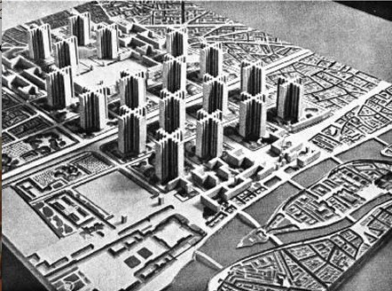
Image taken from arc1.uniroma.it / Le Corbusier, Plan Voisin, Paris 1935.

One of the most alarming overtones heard among the ranks of the most radical sustainability proponents is the notion that the severity of the environmental crisis, coupled with the needs of today’s profoundly transformed society, call for a complete redesign of the built environment. The rejection of the past and its structures is a familiar rallying cry of the modernist thinkers, best exemplified by Corbusier’s Plan Voisin. Luckily, most sustainability proponents exercise considerably more constraint in their public proclamations, but one is often left with the impression that appreciation of the existing urban fabric does not rank very high on the sustainability agenda.

Related to that is another point of concern deriving from the narrow interpretation of sustainability. Quite frequently, particularly during the last couple of years, sustainability is equated with minimising energy and resource use. I am afraid that applied to the urban realm, the dictate of resource efficiency can produce similar outcomes to those generated by the push for greater functionality which dominated modernist city planning during the previous century. Following such rationale, for instance, one can easily make the argument for the wholesale replacement of the energy inefficient historic housing stock of many cities around the world.

Another analogy between modernist and sustainability ideologists is their shared belief in technology as a main tool for accomplishing societal goals. This time around, the reinstatement of technology as a liberating force comes not in the form of a shiny machine, but as a delicate organic membrane wrapped around the body of the building, a network of sensors draped over the city governing the self-regulation of its interlinked systems. The digital delirium of the twenty-first century has replaced the fetishism of the machine championed one hundred years ago.

Recently, the notion of flexibility and fluidity characterizing natural systems has been pulled in to serve as an inspiration of architectural and urban design. The fluency of space, both interior and exterior, has been emphasized as form-shifting buildings and nomadic public spaces adjust to the ever-changing requirements of a highly dynamic urban reality. The permanence of architecture and the built environment, one of the city’s most reassuring psychological traits, is replaced by an overly responsive environment eager to please the users in whichever possible way.

These are just a few thoughts, admittedly rather dark ones. Overall, I am rather skeptical of the ability of societies to learn from the past. Yet I hope that the experience from the attempts to redesign the city during the last century could bring some humility and insights to our efforts toward sustainable design.

This Guest post by Kiril Staniov forms part of the discussion in the single-blogs series on Ecological Urbanism.

----


Kiril Stanilov holds a Professional Diploma in Architecture from the University of Architecture, Civil Engineering and Geodesy, Sofia; a Master of Community Planning from the University of Cincinnati; and a PhD in Urban Design and Planning from the University of Washington. From 1998 to 2008 he was an Assistant and an Associate Professor in Planning at the University of Cincinnati where he taught courses in urban design, physical planning, and contemporary urbanization.
Kiril Stanilov’s research interests are centered on explorations of contemporary patterns of urban growth and change, and the role played by public policies in shaping urban form transformations.

Kamis, 22 April 2010

Urban Defender

Leaving the mark in the city is part of the identification process. The memory hels to orientate and shape a personal image of the city. The image is shape through the interaction and influenced by a whole palet of factors. On frequently used routes this memory is refreshed and sharpened where as it can fade in certain locations. The idea to mark a place as mine, yours or theirs can take a number of shape and we are all very familiar with the fences, walls and signs imposing restriction on everyday activities. However usually this becomes more obvious with temporary restrictions or abrupt changes. Groups and institutions can impose restrictions for other, but not only using fences. Gated communities are only one way to mark a wealthy area another solution is for example the house prices or not to provide public transport.
But also on a daily basis marks are left on the way. The graffiti or the tag on the wall, the carved name in the tube seat or the note on the toilet door. We can also leave the digital marks with Brightkite or now with Tales of Things leave a mark with a digital content.


Image taken from Urban Defender page / An earlier prototype and it's content.

A game developed at the Zürcher Hochschule der Künste id picking up on this idea of marking the territory and let you play the city very much in the sense of social gangs. Urban Defender is a location aware ball game that lets you virtually mark urban elements by trowing the ball on the wall. The players get an audio and visual feedback from the ball on who 'owns' the feature and it can then be taken over.
"The ball itself is a prototype combination of an Arduino, Accelerometer, vibration motor, LEDs, XBee, batteries, and wire all packed inside of an industrial rubber gym ball." (hack a day) The idea is that via the GPS the bal is aware of its location and processes the data accordingly.
A detailed documentation of the construction and programming process can be found on the Urban Defender page.
However much you know would liket to go out and play, it is still a prototype. A few problems the developer team still has to solve. One is definitely the GPS. Having worked with the technology a bit, one would need an extremely good receiver to geta clear signal, for not talking about on witch side of the road you are throwing the bal at the wall. The urban environment is tricky for the GPS and reflections on tal facades can easily give you a wrong position.
Nevertheless, this is a gaming concept that captures the imagination and I would ove to see it developed further. Game On!


Found via Pop up City.

Jumat, 26 Maret 2010

Book - The Infrastructural City

The city has many different faces and as we all know it cannot be described in one sentence or one equation. It also is not a computer chip, although some recent master plans might have a formal similarity, nor is it a single organism growing for one purpose. It is more of a collective consisting of individuals capable of creating, deciding and moving. It is organized, as one currently would describe it, in networks and some of the elements of the collective are private where as other are public, in the sense of providing service to a larger group of the collective. Within the network these services manifest in infrastructure serving the public. In a number of ways this infrastructure tells a large part of the story about the collective or the city as such. In the sense of 'Show me your infrastructure and I tell you who you are.' the book 'Infrastructural City - Networked Ecologies in Los Angeles' edited by Kazys Varnelis and published by Actar tells the story of an urban area. This specific focus reveilles so much about the society that invented it, it is fascinating and sometimes shocking. From mobile phone tower camouflaged as palm trees to engineered tarmac graffiti everything is revealed and sets the context to the 21st century society.


Image by single-blogs / Book spread.

The analysis comes in three parts, Landscape, Fabric and Objects. The titles do not obvious characterize the content though. I haven't really figured out what the organisation is. This, however doesn't matter because you should read them all, or the reader can jump from one to another and back. It is not a necessarily linear read and this is a relief, because its content is extremely dense.
The detailed descriptions are accomplished with three elements describing the linear city. Lane Barden follows linear infrastructure elements and explores the city. This gives a very specific angle on the subject, but also helps high lighting due to the focus. The lines are documented by a map and sequential photographs as well as a little bit of background text. In a very calm and focused way the city takes shape along these lines. The elements are, the river, the street - Wilshire Boulevard and the trench - freight transport.


Image by single-blogs / Book spread.

In 'Counting (on) Change' Roger Sherman describes and illustrated the pace at which change takes place and how planning and design professionals fall behind the latest trends and are doomed to react rather than help shape the future. He sais: "For architects, the time has come to recognize, finally, that contemporary urbanism is better rethought around conceptions of progress and potential - via design strategies for unfolding the future - rather than by another utopian horizon." In a series of detailed diagrams the negotiations and changes over land and ownership at a number of scales.
The book ends with a report on probably the biggest and most vital piece of infrastructure in the city of Los Angeles. 'The Trench' is the ten miles long transport corridor Bringing the arriving goods from the port out of the city to distribution centres that will feed the rest of North America. The specs are impressive, more than $200 billion in cargo are transported on this route, but it is largely unnoticed as a feature in the city. It used to be a dominating feature due to its rail crossings and activity of the trains, but nowadays all the trains run in a fifty feet wide and thirty-three feet deep cut on a lower city level out of sight. And still it is probably the main artery of the city. Lane Barden sais: "It would be realistic to argue that the trench is central to the everyday efficiency of global capitalism."
In this sense, the city might as well be a machine.

This is a book on urban infrastructure that not only describes the elements, but positions them in a social and cultural city context. The approach is not about isolating elements to simplify it, rather it is about piecing it together to help shape an understanding of the whole. It really is a book about the city, the city of the everyday.

For other reviews see: archidose or we-make-money-not-art.


Varnelis, K., 2009. The Infrastructural City. Networked Ecologies in Los Angeles, Barcelona: Actar.

Stuttgart 24

A timeLapse portrait of the city of Stuttgart in Germany. It is a film by Christoph Kalck & Jascha Vick, with music by Sebastian Bartmann and shows the city of the period of 24 hours. A selection of 20 locations make it a divers portrait ranging from market hall to zoo, to train station and cross road. The feature of the tiny schematic clock in the bottom corner provides a good sense of orientation in temporal terms.
The movie was produced at the Stuttgart Media University (hdm-stuttgart.de) in the study course Audiovisual Media from October 2009 till January 2010. The material is shot with a Canon EOS-1D Mark II.
Interesting also is the map provided with the locations of the shootings. This can provide some sort of orientation. However, without the aspects of time and sequence there is something missing.

Kamis, 18 Maret 2010

The Identity of the Place

The new Monu Magazine comes with a beautiful quote describing the characteristics of the city as a particular locally sourced parameter that lives and breathes with the citizens.
"Most of our cities are shaped by a particular set of values that does not necessarily lead to high quality urban spaces, but instead to scary, ethically unacceptable and distorted forms." (MONU issue #12, )
This is something we all experience on a daily basis and therefore are very familiar with. However it doesn't stop there. We also contribute to our surrounding, we are part of it. At least since 'The Social Logic of Space' by Hillier and Hanson we also have an attempt to describe and characterize this phenomenon. It it is not the only attempt, but one that claims to be fundamental and 'scientific' i.e. mathematical. But still, it is based on the static concept of the space as a given entity. This doesn't fit together with Open Source, Free Content or User Participation. To some extend with the emerging filed of spatial dynamics research based on the new location awareness technologies is to look into this very same field. Since it focuses on the activity of the citizens directly they finally play the important role in the description of the urban environment. It really comes back to 'You are the City'.

You can brows the magazine on YouTube, for convenience I have simply embedded the clip below, so go a head a flip through the pages.

Kamis, 11 Maret 2010

Local Tweets Between the Buildings of Central London

The Twitter data is still top of the list and we are experimenting currently with different models in Google Earth.
Here we have a version using the 3D London Model developed here at CASA.
In the flight through you can now see where the tweets actually were sent and in what context. It covers currently central London using approximately 10,000 tweets only, because we are experiencing performance problems. We are working on it and hopefully will have a solution shortly.


Rabu, 03 Maret 2010

Book - Cities of Change

A truly nice book worth having. Well, yes I know it is odd to start the review with the conclusion, but there is not much more needed to be said. A Birkhauser publication usually would not let you down and this one is no exception. But however, a good publication also needs some good substance to it and only if the two meet up it will be a truly nice book. Probably the only thing irritating is the preface, which you'd better skip because this puts you definitely in the wrong mind set.
'Cities of Change Addis Ababa - Transformation Strategies for Urban Territories in the 21st Century' by Marc Angelil and Dirk Hebel is, as mentioned above by Birkhauser. The book reports on the progress of an ongoing research at the ETH under Professor Marc Angelil (His practice is AGPS). The work published here is the result of three years of student work dating from the years 2006/07, 2007/08 and 2008/09. The introduction summarizes: "The research investigates the performance of cities in view of resource fluxes - the interplay and transformation of stocks and flows of recourses according to changing parameters in time." The reoccurring 'awareness' here really is "...that the only constant is change, ..."


Image by single-blogs / Cities of Change Addis Ababa book cover.

Since this is research conducted in the learning environment with students it has adopted a rather strict and structured approach. This makes perfect sense, in the light of changing groups of students over the duration of the investigation, but especially to allow for a structured leaning environment, while still keeping an open mind for the research. This is a very challenging setup, but I believe this publication demonstrates that any academic research short comings are definitely made up by the quality of the students learning output. It is to some extend a catalogue of student work produced, but the integration as research work is so clever that you wont necessarily notice.
The investigation is structured in two trajectories: "The first ... follows the principle of conducting in-depht academic work in specific fields of inquiry, highlighting particular themes and integrating input from supporting disciplines. THe second trajectory, on questions of urban design, situates the work in the context of design research studio, a workshop setting in which concepts are tested through specific design propositions, aiming for the synthesis of findings from an array of fields." Clearly the publication explores the intersection of the two trajectories. This is organised in seven topics called the 'flux model'. These areas of change are: Stocks and flow of 'people', 'space', 'material', 'capital', 'information' and 'energy'. Each chapter is introduced with a theoretical text, outlining and extending on the explanations given in the introduction part. Mixed with the design projects each chapter also contains theoretical, subject or contextual text pieces.
The surprising element here probably is that the publication does not close with a summary or conclusion. But probably this has to be looked for in the introduction, like in this review, the important things can be said up front without sliming away any of the interest for the further content.
To open the debate here, one of the points I believe to be important to discuss is the structure chosen for such a research project. As outlined before, the context of design studio work clearly has its requirements, but for a truly 'in flux' practice the static outline of the seven chapters can probably not sustain itself over a longer period, since "...that the only constant is change, ..."


Image taken from Google Maps / Addis Ababa aerial view of the city centre.


Angelil, M.M. & Hebel, D., 2009. Cities of Change: Addis Ababa: Transformation Strategies for Urban Territories in the 21st Century, Birkhauser Verlag AG.