Time lapse video, as the title suggests, is much more dramatic as a time collapse. But its not far off and the notion of time folding into, or between the frames could be quite an interesting term. All of them imply the dropping of steps or frames, quite beautifully.
Video shot and directed by by Jean Grimard Gauthereau on Vimeo. He actually also composed the music to with the clip. It is great and creates a beautiful ambient to go with the flow of the scenery. He has some more very lovely clips on his vimeo page, for example the 'Like a Dream'.
Tampilkan postingan dengan label urban. Tampilkan semua postingan
Tampilkan postingan dengan label urban. Tampilkan semua postingan
Kamis, 05 Mei 2011

Selasa, 03 Mei 2011
Book - Urban Tomographies
What has the study of urban phenomenons in common with medical examination? Both could be described as studying a 'body' and trying to find explanations of it's 'functions' in the wider context of 'elements'. This is in both areas a rather practical and realists view with a dramatic functionalists angle.
The rational definition of the city as a body, as for example discussed HERE, has its fascination and many famous urbanists are or have linked to this visualisation. It does convey a certain familiarity in its illustration. However it is far from an abstraction and thus is not very helpful. It only shifts the problem in question from one complex into the other one.

Image taken from Wikipedia / Computed tomography of human brain, from base of the skull to top. Taken with intravenous contrast medium.
However, since both fields are struggling with their respective complexity it could be an option to transfer techniques for examination. This is what Martin Krieger proposes in his new book 'Urban Tomographies' published by University of Pennsylvania Press 2011. Krieger proposes to transfer the techniques of exploring phenomenons through a large number of examples as for example used in CT scans, a technique where organs or other 'elements' are envisioned through numerous individual slice images. It is used to generate a three-dimensional image of the inside of an object from a large series of two-dimensional X-ray images taken around a single axis of rotation.
Basically many small frames are used to piece together the larger whole. This is useful since organs can be visualised and examined without actually having to open. These sort of scans are often used in parts of the human body like the brain where surgery is extremely difficult.
Transferring this technique, with all the necessary alterations, to the field of urban analysis is an intriguing proposal. Especially in the context of the current hype of massive data sets and large scale collections, the term tomography seems an appropriate umbrella. It already has its coining which is relatively balanced. However literally translated it would be closer to something like a laydar scan or mesh model used for 3d representation of urban environments such as in the lates OVI Map 3D.
Krieger's interpretation or migration however, is going further and proposed a more applied and somehow qualitative rooted interpretation of the concept. Many little documentations of the topic to investigate will together represent the larger whole not only physical but also socially and culturally. He explains: "Urban tomography, with its dense and multiple perspectives in space and time and type, allows for exploratory analysis of the world in front of us. ... Multiple perspectives viewed in parallel, and re-viewed, allow for seeing it all, again and again, so that you begin to figure out what it is you are seeing: flows, phenomena, types - not individuals."

Image taken from Urban Tomographies / Urban Tomographies store front
In his investigations Krieger focuses on Los angeles and includes photography as his main method or study. Besides this he also integrates sounds and the recording thereof into his investigations.
The book begins by introducing tomographic methods and the principles behind them, which are taken from phenomenological philosophy. It draws from the examples of Lee Friedlander and Walker Evans, as well as Denis Diderot, Charles Marville, and Eugène Atget, who documented the many facets of Paris life in three crucial periods. Rather than focus on singular, extraordinary figures and events as do most documentarians, Krieger looks instead at the typical, presenting multiple specific images that call attention to people and activities usually rendered invisible by commonality. He took tens of thousands of photographs of industrial sites, markets, electrical distributing stations, and storefront churches throughout Los Angeles. He also recorded the city's ambient sounds, from the calls of a tamale vendor to the buzz of a workshop saw. Krieger considers these samples from the urban sensorium in this innovative volume, resulting in a thoughtful illumination of the interplay of people with and within the built environment. With numerous maps and photographs, as well as Krieger's unique insights, Urban Tomographies provides an unusually representative and rounded view of the city.

Image taken from Urban Tomographies / Book cover.
Krieger, M.H., 2011. Urban Tomographies, Philadelphia: University of Pennsylvania Press.
The rational definition of the city as a body, as for example discussed HERE, has its fascination and many famous urbanists are or have linked to this visualisation. It does convey a certain familiarity in its illustration. However it is far from an abstraction and thus is not very helpful. It only shifts the problem in question from one complex into the other one.
Image taken from Wikipedia / Computed tomography of human brain, from base of the skull to top. Taken with intravenous contrast medium.
However, since both fields are struggling with their respective complexity it could be an option to transfer techniques for examination. This is what Martin Krieger proposes in his new book 'Urban Tomographies' published by University of Pennsylvania Press 2011. Krieger proposes to transfer the techniques of exploring phenomenons through a large number of examples as for example used in CT scans, a technique where organs or other 'elements' are envisioned through numerous individual slice images. It is used to generate a three-dimensional image of the inside of an object from a large series of two-dimensional X-ray images taken around a single axis of rotation.
Basically many small frames are used to piece together the larger whole. This is useful since organs can be visualised and examined without actually having to open. These sort of scans are often used in parts of the human body like the brain where surgery is extremely difficult.
Transferring this technique, with all the necessary alterations, to the field of urban analysis is an intriguing proposal. Especially in the context of the current hype of massive data sets and large scale collections, the term tomography seems an appropriate umbrella. It already has its coining which is relatively balanced. However literally translated it would be closer to something like a laydar scan or mesh model used for 3d representation of urban environments such as in the lates OVI Map 3D.
Krieger's interpretation or migration however, is going further and proposed a more applied and somehow qualitative rooted interpretation of the concept. Many little documentations of the topic to investigate will together represent the larger whole not only physical but also socially and culturally. He explains: "Urban tomography, with its dense and multiple perspectives in space and time and type, allows for exploratory analysis of the world in front of us. ... Multiple perspectives viewed in parallel, and re-viewed, allow for seeing it all, again and again, so that you begin to figure out what it is you are seeing: flows, phenomena, types - not individuals."
Image taken from Urban Tomographies / Urban Tomographies store front
In his investigations Krieger focuses on Los angeles and includes photography as his main method or study. Besides this he also integrates sounds and the recording thereof into his investigations.
The book begins by introducing tomographic methods and the principles behind them, which are taken from phenomenological philosophy. It draws from the examples of Lee Friedlander and Walker Evans, as well as Denis Diderot, Charles Marville, and Eugène Atget, who documented the many facets of Paris life in three crucial periods. Rather than focus on singular, extraordinary figures and events as do most documentarians, Krieger looks instead at the typical, presenting multiple specific images that call attention to people and activities usually rendered invisible by commonality. He took tens of thousands of photographs of industrial sites, markets, electrical distributing stations, and storefront churches throughout Los Angeles. He also recorded the city's ambient sounds, from the calls of a tamale vendor to the buzz of a workshop saw. Krieger considers these samples from the urban sensorium in this innovative volume, resulting in a thoughtful illumination of the interplay of people with and within the built environment. With numerous maps and photographs, as well as Krieger's unique insights, Urban Tomographies provides an unusually representative and rounded view of the city.
Image taken from Urban Tomographies / Book cover.
Krieger, M.H., 2011. Urban Tomographies, Philadelphia: University of Pennsylvania Press.
Rabu, 27 April 2011
Royal Wedding - London is Dressing up
London is almost ready for the Royal Wedding later this week on the 29th of April. Preparations have been going on for weeks and the media is completely ull with details and stories covering the latest developments. Prince William is getting married to his long term partner Kate Middleton in a ceremony at Westminster Abbey. The event is expected to be the biggest of its kind ever and attract a world wide audience of some 2 billion viewers on TV, radio and internet. Copmared the wedding of Prince Charles and Princess Diana aracted a world wide audience of 750 million and the last Superbowl in America set the national audience record at 111 million viewers.

Image taken from the hotmeganews / The flags along Regent Street in London transforming the space and time warping it back to the beginning of the last century.
Of course digital media is part of this these days and the official web page is central to this. However, the twitter feed will come from @clarencehouse. The general twitter tag for the occasion is #rw2011 or the #royalwedding. The official facebook page with 360'000 likes is also covering the events in detail.

Image taken from the the Sun / The plan of the route between Buckingham Palace and Westminster Abbey as chosen. Guests and the wedding couple will be traveling along it. Prince William and Kate Middleton will be traveling in the golden carriage if the weather is nice otherwise in a car.
The dressing up of the city as the venue is of course most obvious with the decoration that has been put of in the lead up to the Royal Wedding. Most notably are the coverage of British flags as shown above in Regent Street. It transforms the place completely and give a very different feeling from the usual Christmas decoration. The flag as such still has this official and important touch to it. It almost turns back the time to represent London one hundred or at least fifty years ago with a bit of steam and fog.
Then there is the change in security. It already is a big topic in London anyway but now police have stepped up and security has been tightened. The main focus is on the route between Buckingham Palace and Westminster Abbey of course, but also other major areas and attractions are being prepared.

Image taken from the toledoblade / Security is being checked and implemented across London.
There is a lot of money involved an additional guest in London and the UK in general are expected to help boost the economy.
The goverment is also very much involved with a lot of hopes to gain some benefit from the event directly. A number of oficial goverment web page feature the wedding as their current top priority. For example HNE on how to stay save during the Royal Wedding of course or DirectGov with the public service view on it.
With the day being declared an additional day off there is more time for employees to spend money. Merchandising is expected to make huge amounts by selling all the flags and cups and plates. The BBC says: "Restaurateurs and hoteliers can now look forwards to a two year bulge in tourism numbers, with the 2011 wedding to be followed by the 2012 Olympics." The UK Gift Company, which specialises in Royal items anticipates an upturn in business of about 30% to 40%.

Image taken from the BBC / Seating plan for the guest at Westminster Abbey. The structuring of the seating in groups is following clear ordering principles.
The seating is following a detailed ordering system of who is sitting where and next to whom. The arrangements have taken weeks of negotiation and preparations. 1900 guest will be seated. For everyone else there is an app for that, to take you round Westminster Abbey in 3D with a lot of background information. However, it will cost you a few bucks.

Image taken from the BBC / Layout of the cutlery on the table for Prince William and Kate's wedding reception.
Of course the planning of details goes further into details with small gestures and practices. From a city scale right down to how to dress for the wedding, how to greet and of course how to eat. The Royal Wedding has its very own layout of cutlery on the wedding reception table. The BBC has the details on how to manage all the different pieces. However, the BBC comments: "It's quite simple - start at the outside and work in as the meal progresses"
The guest list has only been released, but very much in the nature of the time has shortly after ben declared public data and the Guardian data blog features it, with the option to download the list as free data. Maybe you get a great viz out of it!
Visualisation using many eyes by IBM / Bubble chart using the open data of the Wedding invitation list, coloured by nationality. Click to interact.
The organisation of the wedding reflects the strong hierarchical organisation of the Royal concept. Both practically and socially, it is a clear structure of ranks with the Queen at the top end and this will be reinforced through practice on the day. Practice is feeding into al elements of the wedding, from invitation to seating, even to traveling, there is a very strict guide on who is leaving when for Westminster Abbey. Of course the most practical way is the addressing of people respecting the individual rank. The five levels after the Royals are: the Duke / Duchess, followed by the Marquess / Marchioness, followed by the Earl / Count or Countess, followed by Viscount / Viscountess, followed by Baron / Baroness, as described by Debretts.
There is a lot more to the Royal Wedding than just a couple getting married. It is not about the two individuals Prince William and Kate Middleton, but about the bigger idea of Royal and State. The event is a far reaching demonstration of a very old aristocratic practice and represents the position of England in general as part of the world.
This demonstration solely is based on practice, routines and established rites and in this case culminate in the wedding ceremony. This is the reason for the practice to be of such importance because only through its celebration it can be established and such an occasion is the perfect practice this structure can celebrate. The bigger idea is the hope that this wedding will put everything in to place.
This of course centres on the Royal family but reaches out from the palace to the wider London area, to national politics, to the society of this country and its related nations, to international politics and ultimately to the world. With this there are a lot of people and groups very keen on getting some positive benefit directly from this ceremony foremost probably the Prime Minister David Cameron and his Conservative Party as they are trying to deliver massive financial cuts and keep the people quite, but definitely other such as Boris Johnson for London and the upcoming Olympics 2012 and then of course the rehearsal of hierarchical structures will act as a boost to older traditions and society structures probably feeding into the Big Society idea the conservatives are trying to sell. It of course a big celebration of everything that has rank and name, but it pulls in the normal person too. Formost with the announcement of the Royal Wedding day to be a national bank holiday, an extra day off. With this you'll be buying a lot of good will. Of course then you also have the representatives and identification figurs featuring at the Royal Wedding, such as the Victoria and David Beckham, Joss Stone, Rowan Atkinson, Guy Ritchie or of course Sir Elton John.
These practices are employing symbols and simple seemingly elements such as flags all the way down Regent Street, but exactly this is what lets people create their identity and reinforces a practice of space and lets the Wedding become a great event.
Image taken from the hotmeganews / The flags along Regent Street in London transforming the space and time warping it back to the beginning of the last century.
Of course digital media is part of this these days and the official web page is central to this. However, the twitter feed will come from @clarencehouse. The general twitter tag for the occasion is #rw2011 or the #royalwedding. The official facebook page with 360'000 likes is also covering the events in detail.
Image taken from the the Sun / The plan of the route between Buckingham Palace and Westminster Abbey as chosen. Guests and the wedding couple will be traveling along it. Prince William and Kate Middleton will be traveling in the golden carriage if the weather is nice otherwise in a car.
The dressing up of the city as the venue is of course most obvious with the decoration that has been put of in the lead up to the Royal Wedding. Most notably are the coverage of British flags as shown above in Regent Street. It transforms the place completely and give a very different feeling from the usual Christmas decoration. The flag as such still has this official and important touch to it. It almost turns back the time to represent London one hundred or at least fifty years ago with a bit of steam and fog.
Then there is the change in security. It already is a big topic in London anyway but now police have stepped up and security has been tightened. The main focus is on the route between Buckingham Palace and Westminster Abbey of course, but also other major areas and attractions are being prepared.
Image taken from the toledoblade / Security is being checked and implemented across London.
There is a lot of money involved an additional guest in London and the UK in general are expected to help boost the economy.
The goverment is also very much involved with a lot of hopes to gain some benefit from the event directly. A number of oficial goverment web page feature the wedding as their current top priority. For example HNE on how to stay save during the Royal Wedding of course or DirectGov with the public service view on it.
With the day being declared an additional day off there is more time for employees to spend money. Merchandising is expected to make huge amounts by selling all the flags and cups and plates. The BBC says: "Restaurateurs and hoteliers can now look forwards to a two year bulge in tourism numbers, with the 2011 wedding to be followed by the 2012 Olympics." The UK Gift Company, which specialises in Royal items anticipates an upturn in business of about 30% to 40%.
Image taken from the BBC / Seating plan for the guest at Westminster Abbey. The structuring of the seating in groups is following clear ordering principles.
The seating is following a detailed ordering system of who is sitting where and next to whom. The arrangements have taken weeks of negotiation and preparations. 1900 guest will be seated. For everyone else there is an app for that, to take you round Westminster Abbey in 3D with a lot of background information. However, it will cost you a few bucks.
Image taken from the BBC / Layout of the cutlery on the table for Prince William and Kate's wedding reception.
Of course the planning of details goes further into details with small gestures and practices. From a city scale right down to how to dress for the wedding, how to greet and of course how to eat. The Royal Wedding has its very own layout of cutlery on the wedding reception table. The BBC has the details on how to manage all the different pieces. However, the BBC comments: "It's quite simple - start at the outside and work in as the meal progresses"
The guest list has only been released, but very much in the nature of the time has shortly after ben declared public data and the Guardian data blog features it, with the option to download the list as free data. Maybe you get a great viz out of it!
Visualisation using many eyes by IBM / Bubble chart using the open data of the Wedding invitation list, coloured by nationality. Click to interact.
The organisation of the wedding reflects the strong hierarchical organisation of the Royal concept. Both practically and socially, it is a clear structure of ranks with the Queen at the top end and this will be reinforced through practice on the day. Practice is feeding into al elements of the wedding, from invitation to seating, even to traveling, there is a very strict guide on who is leaving when for Westminster Abbey. Of course the most practical way is the addressing of people respecting the individual rank. The five levels after the Royals are: the Duke / Duchess, followed by the Marquess / Marchioness, followed by the Earl / Count or Countess, followed by Viscount / Viscountess, followed by Baron / Baroness, as described by Debretts.
There is a lot more to the Royal Wedding than just a couple getting married. It is not about the two individuals Prince William and Kate Middleton, but about the bigger idea of Royal and State. The event is a far reaching demonstration of a very old aristocratic practice and represents the position of England in general as part of the world.
This demonstration solely is based on practice, routines and established rites and in this case culminate in the wedding ceremony. This is the reason for the practice to be of such importance because only through its celebration it can be established and such an occasion is the perfect practice this structure can celebrate. The bigger idea is the hope that this wedding will put everything in to place.
This of course centres on the Royal family but reaches out from the palace to the wider London area, to national politics, to the society of this country and its related nations, to international politics and ultimately to the world. With this there are a lot of people and groups very keen on getting some positive benefit directly from this ceremony foremost probably the Prime Minister David Cameron and his Conservative Party as they are trying to deliver massive financial cuts and keep the people quite, but definitely other such as Boris Johnson for London and the upcoming Olympics 2012 and then of course the rehearsal of hierarchical structures will act as a boost to older traditions and society structures probably feeding into the Big Society idea the conservatives are trying to sell. It of course a big celebration of everything that has rank and name, but it pulls in the normal person too. Formost with the announcement of the Royal Wedding day to be a national bank holiday, an extra day off. With this you'll be buying a lot of good will. Of course then you also have the representatives and identification figurs featuring at the Royal Wedding, such as the Victoria and David Beckham, Joss Stone, Rowan Atkinson, Guy Ritchie or of course Sir Elton John.
These practices are employing symbols and simple seemingly elements such as flags all the way down Regent Street, but exactly this is what lets people create their identity and reinforces a practice of space and lets the Wedding become a great event.
Rabu, 23 Februari 2011
The City Never Sleeps - Augmented Graffiti
Graffiti artist Marc C. Woehr and Interaction Designer Achim Kern have collaborated on this project to augment graffiti using light. The installation with the title 'The City Never Sleeps' features a Woehr drawing and uses projection to light paint into it.
It is quite amazing how the light has the power to completely change the scene. It is possible to turn the whole thing inside out by lighting up the facades of the buildings and taking them out of the darkness or especially when the sky behind the buildings becomes the focus of the activity.

Image taken from Achim Kern / Impression form the exhibition where 'The City Never Sleeps' was shown. The artist were not atisfied with the exhibition pace, not dark enough, so they prduced a second visual shich can be seen HERE.
Graffiti feature everywhere in the urban scene and are already quite a lively part of the street scape, since they apear and disappear on a short term basis. Adding the temporality of the lighting this could grow into a fully blown interactive urban landscape using augmented reality or tagging technologies. Maybe even in combination as demonstrated by the Tales of Things team at the last CASA Seminar. Martin de Voot demonstrated how to use QR tags as AR tags.
With technology becoming available, especially for examples mobile projectors this could be a fantastic feature for the urban context. Products are available for examples from Microvision.
It is quite amazing how the light has the power to completely change the scene. It is possible to turn the whole thing inside out by lighting up the facades of the buildings and taking them out of the darkness or especially when the sky behind the buildings becomes the focus of the activity.
Image taken from Achim Kern / Impression form the exhibition where 'The City Never Sleeps' was shown. The artist were not atisfied with the exhibition pace, not dark enough, so they prduced a second visual shich can be seen HERE.
Graffiti feature everywhere in the urban scene and are already quite a lively part of the street scape, since they apear and disappear on a short term basis. Adding the temporality of the lighting this could grow into a fully blown interactive urban landscape using augmented reality or tagging technologies. Maybe even in combination as demonstrated by the Tales of Things team at the last CASA Seminar. Martin de Voot demonstrated how to use QR tags as AR tags.
With technology becoming available, especially for examples mobile projectors this could be a fantastic feature for the urban context. Products are available for examples from Microvision.
Rabu, 16 Februari 2011
Book - Urban Living
Not only since the dawn of the financial crisis are the high street and office spaces under pressure. Flexible working schemes and online shopping also pull revenue out of these traditional markets. As a result, especially with shops the small and independent units are disappearing and big chains fill the city centres. However, on the fringes, more and more empty units, both business and retail are left unused.
The architecture in many of these buildings has been rather specific and very clear in its typology about the usage. A shop is a shop and an office building is an office building. But what to do with them if they are empty? They leave massive holes in the urban fabric, simple because they are under used or unused.

Image taken from single-blogs on flickr / Section of 'Living Cubes' by Jan Conradi and Jens Ullersperger.
Together with the idea of the functional city, these usages have established themselves in central city locations taking over and pushing out any other use, including living. As a result most western cities have no, or very little mixed usage in central city locations.
The decline in shops and office needs could be a chance to reestablish pockets of housing in these location in order to reclaim the city centre also as a place for housing. However the main chalenges are the sustainable and typological adaptations of a mono functional area. How to live in an office block?
In an international student competition this question was addressed. The results are summarised in the JOVIS publication 'Urban Living' and give an overview of ideas and concepts to reuse office buildings and develop innovative urban housing concepts.
The competition was sponsored by the 'Immobilienforum Frankfurt' as they have realised the decline as well as the potential. At the time they estimated, that across Germany in the seven most important business locations (Berlin, Duesseldorf, Frankfurt, Hamburg, Cologne, Munich and Stuttgart) more than 10% of office space in prime locations are unused. In cooperation with the Deutsches Architekturmuseum Frankfurt (DAM) the international competition was launched in 2007.


Image taken from single-blogs on flickr / Top: Visualisation of staircase and gangways of 'Canyon Connection' by Jan Becker. Bottom: Floor plan first floor of 'Canyon Connection' by Jan Becker.
The publication showcases 46 projects of great variety, all based on existing office building structures being transformed into housing. As you would expect there is the bare concrete 80ies office block with the dominant structural facade towering over the rest of the street now turning into a gentle and soft host for a variety of living concepts.
The projects show an impressive variety of ways of living. The students have really put some thought into, not only transforming the existing structure but also ways of live and organisation of living. There are a lot of merging activities, working and sleeping overlaps as well as privat and semi public to public space are here conceptually possible in the same space. Often these solutions imply a temporal separation. In this sense time is added as an additional dimension to organisation of living and activity.
Overall concepts fo course bring in the normal suspects, nomade living, nested units, communal concepts, mobile units, green living and so on. However, most of them have a unique twist to it, probably not least because of the unique setting.
It is a great task for students to be challenged by the constraints of such a 80ies monster, but also a very interesting contribution to a ongoing urban discussion. Eventually this scenario will become reality and the vast number of these structures is a chalenge of change.

Image taken from single-blogs on flickr / Urban Living Book Cover, visualisation of the project 'Living Cubes' by Jan Conradi and Jens Ullersperger
Diniawarie, D., 2009. Urban Living: Visionen neuen Wohnens Bilingual., Berlin: Jovis.
The architecture in many of these buildings has been rather specific and very clear in its typology about the usage. A shop is a shop and an office building is an office building. But what to do with them if they are empty? They leave massive holes in the urban fabric, simple because they are under used or unused.
Image taken from single-blogs on flickr / Section of 'Living Cubes' by Jan Conradi and Jens Ullersperger.
Together with the idea of the functional city, these usages have established themselves in central city locations taking over and pushing out any other use, including living. As a result most western cities have no, or very little mixed usage in central city locations.
The decline in shops and office needs could be a chance to reestablish pockets of housing in these location in order to reclaim the city centre also as a place for housing. However the main chalenges are the sustainable and typological adaptations of a mono functional area. How to live in an office block?
In an international student competition this question was addressed. The results are summarised in the JOVIS publication 'Urban Living' and give an overview of ideas and concepts to reuse office buildings and develop innovative urban housing concepts.
The competition was sponsored by the 'Immobilienforum Frankfurt' as they have realised the decline as well as the potential. At the time they estimated, that across Germany in the seven most important business locations (Berlin, Duesseldorf, Frankfurt, Hamburg, Cologne, Munich and Stuttgart) more than 10% of office space in prime locations are unused. In cooperation with the Deutsches Architekturmuseum Frankfurt (DAM) the international competition was launched in 2007.
Image taken from single-blogs on flickr / Top: Visualisation of staircase and gangways of 'Canyon Connection' by Jan Becker. Bottom: Floor plan first floor of 'Canyon Connection' by Jan Becker.
The publication showcases 46 projects of great variety, all based on existing office building structures being transformed into housing. As you would expect there is the bare concrete 80ies office block with the dominant structural facade towering over the rest of the street now turning into a gentle and soft host for a variety of living concepts.
The projects show an impressive variety of ways of living. The students have really put some thought into, not only transforming the existing structure but also ways of live and organisation of living. There are a lot of merging activities, working and sleeping overlaps as well as privat and semi public to public space are here conceptually possible in the same space. Often these solutions imply a temporal separation. In this sense time is added as an additional dimension to organisation of living and activity.
Overall concepts fo course bring in the normal suspects, nomade living, nested units, communal concepts, mobile units, green living and so on. However, most of them have a unique twist to it, probably not least because of the unique setting.
It is a great task for students to be challenged by the constraints of such a 80ies monster, but also a very interesting contribution to a ongoing urban discussion. Eventually this scenario will become reality and the vast number of these structures is a chalenge of change.
Image taken from single-blogs on flickr / Urban Living Book Cover, visualisation of the project 'Living Cubes' by Jan Conradi and Jens Ullersperger
Diniawarie, D., 2009. Urban Living: Visionen neuen Wohnens Bilingual., Berlin: Jovis.
Rabu, 09 Februari 2011
Sorting Shapes and Cleaning up Cities
What would the world look like if we get everything sorted? Things would be tucked away neatly, places are clean, papers sorted and regulations clear. Maybe.
Sorting and cleaning, polishing and updating, pushing and flushing are frequent terms used in design and research and as part of the discussion definitely have a relevance. They convey a certain change and proposition together with implied 'to the better'.

Image taken from Armelle Caron / Paris as it is and sorted.
As usual with terms they can be overused, for things they don't apply or to describe something that is not this way or doesn't even exist. Even more so, they can be over stretched and filled with an missionary believe and practice and followism. This is definitely the case when people start to believe in one of the terms as being the only one, the world saving solution.
Academia is pruned to be a place for sorting and clearing, but on the other hand is also a very messy place. But hey invention and creativity are different beasts altogether. Anyway, it is probably the exchange and the collaboration that prevents ideas and concept to overflow and draining down one of these few juicy terms.

Image taken from Armelle Caron / Tamarac as it is and sorted.
Mapping is one of the very visual disciplines that is fundamentally about ordering and sorting. This is built on a intelectual concept of reference, singularity and ultimately truth. A very helpful strategy actually, with a lot of benefits as an abstract representation, simplified to clarify. Nevertheless, the combination of the terms is lethal in terms of reprojection. The things do no longer add up if the abstraction is reversed as a revitalised self. A map is a map, is a map, is a map.
For not bringing them back we can as well sort them pieces. In any order, as you please, but let them be abstractions.

Image taken from Armelle Caron / MontPellier as it is and sorted.
Armell Caron has produced these wonderfully sorted pieces of sections or urban plans, sorted into order, any order but the previous one. Nights working on the computer tracing and then moving piece by piece with the curser in Illustrator until neatly sorted in rows. Seems like a very meditative work, at least the power of them illustrations suggests this. Works developed 2005 / 2008.
Via PYTR 75, more details on Armell's blog, on socks-studio, urbain-trop-urabain, the map room or on deconcrete.

Image taken from urbain-trop-urabain / City blocks made from wood as a giant puzzle. Probably impossible to sort it exactly in the original way, but there are plenty of variations to mess about.
Sorting and cleaning, polishing and updating, pushing and flushing are frequent terms used in design and research and as part of the discussion definitely have a relevance. They convey a certain change and proposition together with implied 'to the better'.
Image taken from Armelle Caron / Paris as it is and sorted.
As usual with terms they can be overused, for things they don't apply or to describe something that is not this way or doesn't even exist. Even more so, they can be over stretched and filled with an missionary believe and practice and followism. This is definitely the case when people start to believe in one of the terms as being the only one, the world saving solution.
Academia is pruned to be a place for sorting and clearing, but on the other hand is also a very messy place. But hey invention and creativity are different beasts altogether. Anyway, it is probably the exchange and the collaboration that prevents ideas and concept to overflow and draining down one of these few juicy terms.
Image taken from Armelle Caron / Tamarac as it is and sorted.
Mapping is one of the very visual disciplines that is fundamentally about ordering and sorting. This is built on a intelectual concept of reference, singularity and ultimately truth. A very helpful strategy actually, with a lot of benefits as an abstract representation, simplified to clarify. Nevertheless, the combination of the terms is lethal in terms of reprojection. The things do no longer add up if the abstraction is reversed as a revitalised self. A map is a map, is a map, is a map.
For not bringing them back we can as well sort them pieces. In any order, as you please, but let them be abstractions.
Image taken from Armelle Caron / MontPellier as it is and sorted.
Armell Caron has produced these wonderfully sorted pieces of sections or urban plans, sorted into order, any order but the previous one. Nights working on the computer tracing and then moving piece by piece with the curser in Illustrator until neatly sorted in rows. Seems like a very meditative work, at least the power of them illustrations suggests this. Works developed 2005 / 2008.
Via PYTR 75, more details on Armell's blog, on socks-studio, urbain-trop-urabain, the map room or on deconcrete.
Image taken from urbain-trop-urabain / City blocks made from wood as a giant puzzle. Probably impossible to sort it exactly in the original way, but there are plenty of variations to mess about.
Rabu, 29 Desember 2010
Urban Growth - World Models a Trend
Recently large scale models have come back into fashion and researchers around the globe have started to develop different types of urban grows simulations spanning across urban areas, countries and even started looking at a global scale urban growth models.
Of course one of the precedences is the Bucky world model called the "World Game" or the world peace game. Of course this was based on a Dymaxion Map.

Image taken from genekeyes source: scanned by Gene Keyes from cover of
World Game Report, [28 p.], ©1969, Edwin Schlossberg
Photography by Daniel Gildesgame and Herbert Matter /
It was branded a game, but recently scientists have become much more bold and call it a model. They are also not shy of promises of what could be solved by such a large scale everything incorporating algorithm based predictions.
The main problem back then but even more so nowadays is the base data. With the flood of information we have now it is getting more difficult to manufacture a decent working dataset. And of course it would need to cover the past as well as the current state.
The data, as far as recorded would be available but most likely not in the format and resolution required. So to start a lot of foundation work is required and no one seems willing at them moment to invest in this fundamentally important piece of work. everyone whats to get on with the exciting bit of the prediction, that how one makes money.
Even more interesting to look at some of the few existing visualisations of the past urban growth globally. The New Town Institute has put together a flash based visualisation of world wide urban growth of the past 6000 years. This is quite a good starting point and interesting in it self. Have a look how urban areas evolved, declined and reinvented themselves. The database is also online available.
Visualisaion taken from newtowninstitute
Of course one of the precedences is the Bucky world model called the "World Game" or the world peace game. Of course this was based on a Dymaxion Map.
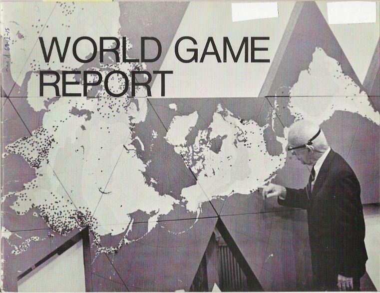
Image taken from genekeyes source: scanned by Gene Keyes from cover of
World Game Report, [28 p.], ©1969, Edwin Schlossberg
Photography by Daniel Gildesgame and Herbert Matter /
It was branded a game, but recently scientists have become much more bold and call it a model. They are also not shy of promises of what could be solved by such a large scale everything incorporating algorithm based predictions.
The main problem back then but even more so nowadays is the base data. With the flood of information we have now it is getting more difficult to manufacture a decent working dataset. And of course it would need to cover the past as well as the current state.
The data, as far as recorded would be available but most likely not in the format and resolution required. So to start a lot of foundation work is required and no one seems willing at them moment to invest in this fundamentally important piece of work. everyone whats to get on with the exciting bit of the prediction, that how one makes money.
Even more interesting to look at some of the few existing visualisations of the past urban growth globally. The New Town Institute has put together a flash based visualisation of world wide urban growth of the past 6000 years. This is quite a good starting point and interesting in it self. Have a look how urban areas evolved, declined and reinvented themselves. The database is also online available.
Visualisaion taken from newtowninstitute
Senin, 22 November 2010
Drift - Morphing City
The ever changing perspective as we navigate the urban landscape is an important feature influencing the perception and in many ways influences how the space we create as we go along are experienced. It's not as if the street is existing, but it is renewed every time as a recreation of itself with a specific take.
Buildings feature in this process consciously as a back drop and the immediate focus is put on the objects whizzing about, to avoid potential collisions. The trajectories of these has to be continuously monitored and one's own path adjusted accordingly. It is a sort of negotiation between the elements that make use of their power to take decisions and with it continuously generate situations.
However, this consuming activity might in the long run is not be the main focus. Unconsciously the main focus might lay on the static frame and the defining elements as parameters of the room for action.
In this beautiful time lapse Theo Tagholm shows an interpretation of this spatiality of places from the perspective of one subject.
As it says in the description "I drift, half awake, half asleep. Moving through the city I recall but have never been to."
The clip is produced by Theo Tagholm, a video artist. He's got some other great video work. As linked here earlier with the clip Still Moving.
Jumat, 22 Oktober 2010
Urban Portrait - Identification
Get your head out and pump up the volume. While vizzing around on ground level following everyday trails from one spot to the next one the overall picture might sometimes get a bit lost. But there are these moments when al of a sudden the sky clears up and things become clear, the focus sharpens and the pattern emerges. While leaving the hedgerows and brick walls far beneath one gets to see what is really out there. The beast we are battling while trying to establish a routine that in the end only lasts while we are on it. So what does it look like then, the urban legend?

Images by Volk / 'The city of sounds, the city of words'
The more you start to identify with the city you live in, I guess the more you become like the city and the city becomes like you. And once more 'You are the City'.
The graphic was produced by Enrico Bonafede from Volk Graphic Studio. It was produced for Radio Citta' Futura.

Images by Volk / 'The city of sounds, the city of words'
via urbansynergies.ca

Images by Volk / 'The city of sounds, the city of words'
The more you start to identify with the city you live in, I guess the more you become like the city and the city becomes like you. And once more 'You are the City'.
The graphic was produced by Enrico Bonafede from Volk Graphic Studio. It was produced for Radio Citta' Futura.

Images by Volk / 'The city of sounds, the city of words'
via urbansynergies.ca
Minggu, 10 Oktober 2010
Periplastic
----
A guest post by David Bruce from davidbrucestudios.com, contributing to the second Ecological Urbanism discussion hosted by Annick Labeca, Taneha Bacchin, DPR-Barcelona and single-blogs.
----
Space is the periplastic medium of the city; forming as necessary to meet the needs of an ever-changing society. Ideas developed by Lefebvre, Gottdiener, Deluze and Bachelard are among those that shape the foundation of contemporary architectural and urban practice. At the height of the urban experiment lie far reaching goals articulated through computational geometries applied to the architectural form. Yet in the wake of these new and engaging visions for the future we remain deeply rooted in existing physical infrastructures and traditional means of engagement. So what does it mean to reconfigure the space of the city in relation to ecological urbanism? And how do everyday citizens, including artists, designers and other professionals, work together to explore new ideas and affect change as we develop the ecological ethos necessary to generate the “new ethic and aesthetic of the urban”?
These are broad questions that require a multidisciplinary approach in order to address complex social, cultural, political and environmental aspects of space in the city. As an artist with an ear to the ground of this discourse I am drawn to spaces where people interact to creatively address these issues. Contemporary artists often work to alter existing infrastructures and create new sites where everyday people engage new ways to view the city. These spaces contribute to the diversification of the everyday experience and in doing so increase the richness of urban environment.
John Roloff’s conceptual studies of piers 15-17 in San Francisco, CA offer a brief insight on this subject. Roloff was trained as a geologist in the 60’s. Over the past 50 years he has employed his knowledge of environmental systems to create art. His work examines relations between man and nature through an array of projects situated somewhere between art, research science and architecture. He specifically engages the concept “synthetic ecology” while integrating a systemic awareness of ecological processes with the built environment. For Roloff, “Synthetic ecology morphs into trans-scientific forms of empathetic aesthetics, meta-ecology, and themes of alignment, indivisibility and equilibrium between living and non-living systems.” As a point of entry into the spatial inquires of ecological urbanism this idea captures something beyond the typical discourse on sustainability to bridge the gap between aesthetics and pragmatism.
I became specifically interested in Roloff’s studies for this site due to a strategic inversion of the pier assembly. The proposed inversion is a didactic sculptural maneuver. It exposes the hidden dimension of the pier’s structural elements by reassembling them upside down on top of the pier along with representations of the marine and terrestrial strata through which the pylons pass. This upturning of the spatial and structural character of the pier creates a site of exposure. The mundane aspect of passage over, onto and off of a pedestrian element of the bay’s infrastructure is suspended by an intrusion of the unusual; an infrastructural presence that punctuates a moment of aesthetic reflection.

Image by John Roloff / Future Exploratorium Site: Pier 15/17, San Francisco, CA
Roloff’s inversion offers a window to the larger questions approached through this series. As concepts of ecology, systems theory and cybernetics transform our perception of the city how do everyday citizens access the infrastructural counterparts of these concepts? If methods of production are subject to mystification, veiling and erasure then how can we expect everyday “users” to develop an awareness of these mechanisms, participate in a dialogue about them and in turn cultivate the ethos necessary for real transformation? In the case of these questions Roloff’s maneuver provides a starting point and a valuable strategy for an exposition of urban complexity. Were there strategically excavated sections of a streetscape exposing below ground systems and the layering of asphalt, concrete, and rubble used to establish a foundation, or meticulously carved away cross sections through the city, these ruptures in the urban matrix could give rise to a new aesthetic appreciation for the complexity of our daily environment; in turn creating new public sites where ideas surrounding urbanism become prevalent topics of discussion. Gordon Matta-Clark was a pioneer of this aesthetic procedure. His “building cut” installations of the 1970’s garnered attention throughout the art, design and architectural community worldwide. What I imagine could be conceptualized as an extension of his procedures into a far more dense amalgamation of civic infrastructure to produce an overwhelming sense of exposure capable of engaging the everyday citizen in new ways of looking at the city.

Image by Gordon Matta-Clark, “Building Cuts” 1970’s
Strategies like Roloff’s inversion or Clark’s building cuts can be designed to function as public sites in which the evolution of building systems, materials and technologies can be highlighted and directly experienced. They are sculptural marks that create windows into the hidden dimension of urban ecosystems as well as primary reconfigurations of the urban matrix that open the system to new possibilities; Roloff’s seeks to inform while Clark’s seeks to disrupt. Both strategies can be of use to the artist, architect and planner aligned with sustainable practices because ecological urbanism must simultaneously seek to maintain some degree of coherence within the established social, political and economic systems, while at the same time challenge these structures in an effort to cultivate a new praxis.
While planning communities remain focused on practical transformations of the cities infrastructure with respect to ecological urbanism, today’s cities must have affordances for spatial experimentation like those presented above. Sites of adaptation, experimentation and exhibition are the materiel analogues of open source programming. Within the existing fabric of the city these sites are often relegated to interstitial spaces between commonly authorized uses. They go unnoticed until an unforeseen artist or subculture engages the site; marking or deploying an unplanned, unusual or unwanted incursion. Spaces like those mentioned above become socially, culturally and politically charged through the action of artists and designers who take an alternative approach to accepted modes of practice. But the marginal status of these spaces and practices is changing. Social entrepreneurs are cultivating, absorbing and transforming them into viable models for generating creative capital.
Scott Burnham is one of those entrepreneurs. Burnham charts innovation at the edge of urban culture. In 2008 he collaborated with Droog Design to curate Urban Play; a public exhibition of “3D Graffiti” placed in the streets and public spaces of Amsterdam. Burnham assembled a team of artists, architects and designers to collaborate in the creation of 12 innovative projects aimed at “Reversing the traditional approach to urban design, in which objects and areas are created explicitly to discourage public interaction and intervention, this collection of objects were created to encourage interaction and physical engagement by the public.”

Image by Urban Play / 2008
Burnham’s approach is one of many aimed at advancing issues of urbanism and public engagement. In the past many of these works would have fallen into the category of gorilla art (and still would be were it not for their assimilation under the umbrella of a design festival). But as these incursions become more prevalent they gain momentum and take on a more mature role in mainstream culture. As the professional community continues to support a multidisciplinary approach to problem solving civic spaces will adapt and artists will continue to transform existing infrastructures into sites where diverse publics can experiment with new technologies, experience the new ways of imaging the city and generate new social relations that alter the urban lexicon.
----
David Bruce from davidbrucestudios.com is an artist living and working in Philadelphia, Pennsylvania while perusing a Masters Degree of Fine Art at Temple University’s Tyler School of Art. His current work revolves around changes in environmental perception and behavior in relation to urbanism, network culture and technology. He received his bachelor’s degree in Urban Planning with a minor in ecology from East Carolina University in 2003. Focusing curatorial interests on the intersection of art, architecture, and urbanism he plays an active role as gallery manager for Temple University’s Exhibition and Public Programs department.
A guest post by David Bruce from davidbrucestudios.com, contributing to the second Ecological Urbanism discussion hosted by Annick Labeca, Taneha Bacchin, DPR-Barcelona and single-blogs.
----
Space is the periplastic medium of the city; forming as necessary to meet the needs of an ever-changing society. Ideas developed by Lefebvre, Gottdiener, Deluze and Bachelard are among those that shape the foundation of contemporary architectural and urban practice. At the height of the urban experiment lie far reaching goals articulated through computational geometries applied to the architectural form. Yet in the wake of these new and engaging visions for the future we remain deeply rooted in existing physical infrastructures and traditional means of engagement. So what does it mean to reconfigure the space of the city in relation to ecological urbanism? And how do everyday citizens, including artists, designers and other professionals, work together to explore new ideas and affect change as we develop the ecological ethos necessary to generate the “new ethic and aesthetic of the urban”?
These are broad questions that require a multidisciplinary approach in order to address complex social, cultural, political and environmental aspects of space in the city. As an artist with an ear to the ground of this discourse I am drawn to spaces where people interact to creatively address these issues. Contemporary artists often work to alter existing infrastructures and create new sites where everyday people engage new ways to view the city. These spaces contribute to the diversification of the everyday experience and in doing so increase the richness of urban environment.
John Roloff’s conceptual studies of piers 15-17 in San Francisco, CA offer a brief insight on this subject. Roloff was trained as a geologist in the 60’s. Over the past 50 years he has employed his knowledge of environmental systems to create art. His work examines relations between man and nature through an array of projects situated somewhere between art, research science and architecture. He specifically engages the concept “synthetic ecology” while integrating a systemic awareness of ecological processes with the built environment. For Roloff, “Synthetic ecology morphs into trans-scientific forms of empathetic aesthetics, meta-ecology, and themes of alignment, indivisibility and equilibrium between living and non-living systems.” As a point of entry into the spatial inquires of ecological urbanism this idea captures something beyond the typical discourse on sustainability to bridge the gap between aesthetics and pragmatism.
I became specifically interested in Roloff’s studies for this site due to a strategic inversion of the pier assembly. The proposed inversion is a didactic sculptural maneuver. It exposes the hidden dimension of the pier’s structural elements by reassembling them upside down on top of the pier along with representations of the marine and terrestrial strata through which the pylons pass. This upturning of the spatial and structural character of the pier creates a site of exposure. The mundane aspect of passage over, onto and off of a pedestrian element of the bay’s infrastructure is suspended by an intrusion of the unusual; an infrastructural presence that punctuates a moment of aesthetic reflection.
Image by John Roloff / Future Exploratorium Site: Pier 15/17, San Francisco, CA
Roloff’s inversion offers a window to the larger questions approached through this series. As concepts of ecology, systems theory and cybernetics transform our perception of the city how do everyday citizens access the infrastructural counterparts of these concepts? If methods of production are subject to mystification, veiling and erasure then how can we expect everyday “users” to develop an awareness of these mechanisms, participate in a dialogue about them and in turn cultivate the ethos necessary for real transformation? In the case of these questions Roloff’s maneuver provides a starting point and a valuable strategy for an exposition of urban complexity. Were there strategically excavated sections of a streetscape exposing below ground systems and the layering of asphalt, concrete, and rubble used to establish a foundation, or meticulously carved away cross sections through the city, these ruptures in the urban matrix could give rise to a new aesthetic appreciation for the complexity of our daily environment; in turn creating new public sites where ideas surrounding urbanism become prevalent topics of discussion. Gordon Matta-Clark was a pioneer of this aesthetic procedure. His “building cut” installations of the 1970’s garnered attention throughout the art, design and architectural community worldwide. What I imagine could be conceptualized as an extension of his procedures into a far more dense amalgamation of civic infrastructure to produce an overwhelming sense of exposure capable of engaging the everyday citizen in new ways of looking at the city.

Image by Gordon Matta-Clark, “Building Cuts” 1970’s
Strategies like Roloff’s inversion or Clark’s building cuts can be designed to function as public sites in which the evolution of building systems, materials and technologies can be highlighted and directly experienced. They are sculptural marks that create windows into the hidden dimension of urban ecosystems as well as primary reconfigurations of the urban matrix that open the system to new possibilities; Roloff’s seeks to inform while Clark’s seeks to disrupt. Both strategies can be of use to the artist, architect and planner aligned with sustainable practices because ecological urbanism must simultaneously seek to maintain some degree of coherence within the established social, political and economic systems, while at the same time challenge these structures in an effort to cultivate a new praxis.
While planning communities remain focused on practical transformations of the cities infrastructure with respect to ecological urbanism, today’s cities must have affordances for spatial experimentation like those presented above. Sites of adaptation, experimentation and exhibition are the materiel analogues of open source programming. Within the existing fabric of the city these sites are often relegated to interstitial spaces between commonly authorized uses. They go unnoticed until an unforeseen artist or subculture engages the site; marking or deploying an unplanned, unusual or unwanted incursion. Spaces like those mentioned above become socially, culturally and politically charged through the action of artists and designers who take an alternative approach to accepted modes of practice. But the marginal status of these spaces and practices is changing. Social entrepreneurs are cultivating, absorbing and transforming them into viable models for generating creative capital.
Scott Burnham is one of those entrepreneurs. Burnham charts innovation at the edge of urban culture. In 2008 he collaborated with Droog Design to curate Urban Play; a public exhibition of “3D Graffiti” placed in the streets and public spaces of Amsterdam. Burnham assembled a team of artists, architects and designers to collaborate in the creation of 12 innovative projects aimed at “Reversing the traditional approach to urban design, in which objects and areas are created explicitly to discourage public interaction and intervention, this collection of objects were created to encourage interaction and physical engagement by the public.”
Image by Urban Play / 2008
Burnham’s approach is one of many aimed at advancing issues of urbanism and public engagement. In the past many of these works would have fallen into the category of gorilla art (and still would be were it not for their assimilation under the umbrella of a design festival). But as these incursions become more prevalent they gain momentum and take on a more mature role in mainstream culture. As the professional community continues to support a multidisciplinary approach to problem solving civic spaces will adapt and artists will continue to transform existing infrastructures into sites where diverse publics can experiment with new technologies, experience the new ways of imaging the city and generate new social relations that alter the urban lexicon.
----
David Bruce from davidbrucestudios.com is an artist living and working in Philadelphia, Pennsylvania while perusing a Masters Degree of Fine Art at Temple University’s Tyler School of Art. His current work revolves around changes in environmental perception and behavior in relation to urbanism, network culture and technology. He received his bachelor’s degree in Urban Planning with a minor in ecology from East Carolina University in 2003. Focusing curatorial interests on the intersection of art, architecture, and urbanism he plays an active role as gallery manager for Temple University’s Exhibition and Public Programs department.
Jumat, 08 Oktober 2010
Art & Urbanism
----
A guest post by Pieter Vandendorpe from PYTR75, contributing to the second Ecological Urbanism discussion hosted by Annick Labeca, Taneha Bacchin, DPR-Barcelona and single-blogs.
----

Image by Xing Danwen / Urban Fiction, image 0 (detail) (2004)
----
Click the image and read more on Urban Lab Global City
A guest post by Pieter Vandendorpe from PYTR75, contributing to the second Ecological Urbanism discussion hosted by Annick Labeca, Taneha Bacchin, DPR-Barcelona and single-blogs.
----
Image by Xing Danwen / Urban Fiction, image 0 (detail) (2004)
----
Click the image and read more on Urban Lab Global City
Senin, 20 September 2010
Book - Urban Interventions, as the Space is Used
Urban spaces are public space, one presumes. Yes? Who owns the space and what does public actually mean in relation to oneself as an individua? How much authority is imposed on the route we travel daily?
In general public space is for everyone, but only in general. In detail this means it is for certain groups acting and behaving in a certain way. Excluding can take many forms and ranges from physical barriers, economical hurdles to social aspect.
The unwritten moral rules are formed in different layers and dependant on numerous factors. Often a temporal aspect is involved to make things more complicated. As a preliminary conclusion space and especially the ruling of is extremely complicated and often near impossible to interpret a the potential user.
However, maybe the question is not the right one, maybe it is not about the rules or regulations. Maybe it is about the agency of the user? What if te question were, what do you want to use it for, could it be used for this? To make a proposa instead of asking how, completely changes the dimension and the dialogue and unlocks a potentially very fruitful conversation between different groups of actors.

Image taken from regardsdusoir / Urban Interventions, 2010, Cover by Gestalten.
The dilemma goes back quite a bitin history and it could be argued that is in parts a child of the modernist city planning. The city is designed as a machine that runs and functions. Its main purpose is serving the residents and visitors, which in turn makes them user. However, the clear lines of the functional city and the meticulous designed links and connections have reached not far enough. The 'Junkspace' (Koolhaas, R., 2002. Junkspace. October, 100, 175-190.) produced in between is taking over and users can't cope with 'Junkspace', they are trained to function in transit only.
To navigate in the modern urban environment creativity is needed and especially action is needed. It has to be an proactive approach, no longer as users citizens have to commute, but a actors. Space is no longer what it looks like but it is what it's used for.
In an awesome new Gestalten publication 'Urban Interventions' the editors Robert Klanten and Matthias Huebner outline exactly how this 'acting' in urban spaces could look like. And from page one (actually page 8) an incredible 'tour d' urbanism' takes you on a journey through other peoples reinterpretation of space. The mere density and variety of the projects presented makes you wane stand up and go out there into the streets and have some fun. It is one of those reading experiences that creap into your mind and things are no longer what they used to be.

Image by Harmen de Hoop / Sandbox, Amsterdam, 1996. Paving stones removed with sand and toys added to create a child's play area.
The book is organised in seven thematic areas that are: Urban Canvas, Localized, Atachments, Public Privacy, Advertised and Natural Ways. Within this structure you can find gems such as Brad Downney's Spontaneous Sculptures - Broken Bike Lane, 2008 Berlin, Slinkachu's Little People, earlier blog post HERE, or Tazro Niscino's temporary rooms usually featuring a public sculture as for example in 'Engel', Basel, 2002.
Other works are more practical like Harmen de Hoop's public space add ons that quip spaces with additional functionality. Similarly practical or transformative is Oliver Bishop-Young's 'Skip Conversions: London, 2008.
One of my favourites is the 'Urban Camouflage' reinterpreting the dimensions of activity in the (public)spaces of hardware stores.

Image by Urban Camouflage / 'Lappen', performed in Stockholm in 2007 /
The book actually doesn't provide the reader with the normally introductive 'rules of the book' and the table of content. Also each project is documented only with the basic project information, but not with any sort of interpretation. Very much in the sense of the introduction it is an explorative approach and how one reads the book is up to each individual. You can read it from front to back though if you desire.
A must read for every urbanist! Go out and have fun, you are the city.
Klanten, R., 2010. Urban Interventions: Personal Projects in Public Places, Die Gestalten Verlag.
In general public space is for everyone, but only in general. In detail this means it is for certain groups acting and behaving in a certain way. Excluding can take many forms and ranges from physical barriers, economical hurdles to social aspect.
The unwritten moral rules are formed in different layers and dependant on numerous factors. Often a temporal aspect is involved to make things more complicated. As a preliminary conclusion space and especially the ruling of is extremely complicated and often near impossible to interpret a the potential user.
However, maybe the question is not the right one, maybe it is not about the rules or regulations. Maybe it is about the agency of the user? What if te question were, what do you want to use it for, could it be used for this? To make a proposa instead of asking how, completely changes the dimension and the dialogue and unlocks a potentially very fruitful conversation between different groups of actors.

Image taken from regardsdusoir / Urban Interventions, 2010, Cover by Gestalten.
The dilemma goes back quite a bitin history and it could be argued that is in parts a child of the modernist city planning. The city is designed as a machine that runs and functions. Its main purpose is serving the residents and visitors, which in turn makes them user. However, the clear lines of the functional city and the meticulous designed links and connections have reached not far enough. The 'Junkspace' (Koolhaas, R., 2002. Junkspace. October, 100, 175-190.) produced in between is taking over and users can't cope with 'Junkspace', they are trained to function in transit only.
To navigate in the modern urban environment creativity is needed and especially action is needed. It has to be an proactive approach, no longer as users citizens have to commute, but a actors. Space is no longer what it looks like but it is what it's used for.
In an awesome new Gestalten publication 'Urban Interventions' the editors Robert Klanten and Matthias Huebner outline exactly how this 'acting' in urban spaces could look like. And from page one (actually page 8) an incredible 'tour d' urbanism' takes you on a journey through other peoples reinterpretation of space. The mere density and variety of the projects presented makes you wane stand up and go out there into the streets and have some fun. It is one of those reading experiences that creap into your mind and things are no longer what they used to be.

Image by Harmen de Hoop / Sandbox, Amsterdam, 1996. Paving stones removed with sand and toys added to create a child's play area.
The book is organised in seven thematic areas that are: Urban Canvas, Localized, Atachments, Public Privacy, Advertised and Natural Ways. Within this structure you can find gems such as Brad Downney's Spontaneous Sculptures - Broken Bike Lane, 2008 Berlin, Slinkachu's Little People, earlier blog post HERE, or Tazro Niscino's temporary rooms usually featuring a public sculture as for example in 'Engel', Basel, 2002.
Other works are more practical like Harmen de Hoop's public space add ons that quip spaces with additional functionality. Similarly practical or transformative is Oliver Bishop-Young's 'Skip Conversions: London, 2008.
One of my favourites is the 'Urban Camouflage' reinterpreting the dimensions of activity in the (public)spaces of hardware stores.
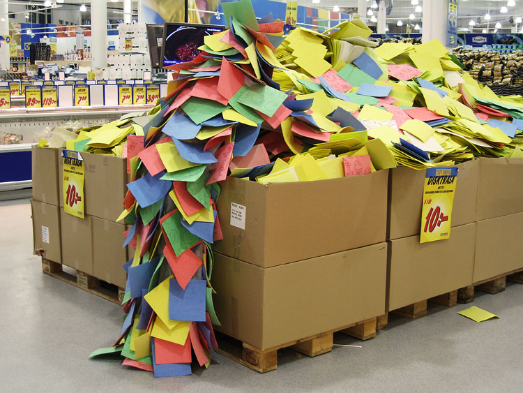
Image by Urban Camouflage / 'Lappen', performed in Stockholm in 2007 /
The book actually doesn't provide the reader with the normally introductive 'rules of the book' and the table of content. Also each project is documented only with the basic project information, but not with any sort of interpretation. Very much in the sense of the introduction it is an explorative approach and how one reads the book is up to each individual. You can read it from front to back though if you desire.
A must read for every urbanist! Go out and have fun, you are the city.
Klanten, R., 2010. Urban Interventions: Personal Projects in Public Places, Die Gestalten Verlag.
Selasa, 14 September 2010
Seattle Tilt Shift
"I'd like to be under the sea in an octopus's garden in the shade ..." Actually this great timeLapse has neither to do with the sea nor with an octopus, but the music used with it is great. This line of text and the tune might follow you through the day though, so be careful.
However, the clip gives you a peep preview of Seattle and as one of the comments on the Vimeo page in respons to the clip goes: "This has that real Seattle light to it..."
I especially like the sequence with the two boats and the pier rocking in the waves, probably only visible in the timeLapse replay.
Senin, 13 September 2010
Book - Hong Kong's Rooftop Villages.
A city is built in many layers. Layers in the temporal sense, but also in layers in the physical sense. The two often go hand in hand. A new area brings a new layer, a new style develops a new typology or new technology allows for a change in usage.
In addition to time more factor can influence the type and number of layers. With more and more people living in cities, the density and pressure in certain areas can be one such factor. Unplanned or ilegal settlements can form spontaneously at different fringe locations. However even in innercity locations, if there is room.
In dense inner city locations however, very seldom one finds an unused spot, at least not on street level, but maybe on roof tops.

Image by Wu/Canham taken from "portrait fro Above' / A view onto a rooftop village from across the road. The building dates from 1958 and is a Cantonese-style shophouse.
A new Peperoni Books publication with the title 'Portraits from Above: Hong Kong's Informal Rooftop Communities' by Rufina Wu and Stefan Canham portraits and documents a series of roof top communities in Hong Kong. The authors work with photographs, drawings and personal stories to tell the story of little villages that exist in the density of an urban mega city, hidden away in the sky.
At least they used to be far away from the streets, hidden on the flat roof of a fifties building, plugging into its infrastructure. Nowadays high rise buildings overshadow these roof tops by far and investment and land speculation threatens there base layer, the original building.

Image by Wu/Canham taken from "portrait fro Above' / A view onto a rooftop village from across the road. Six staircases provide access to this 8 story building that hosts another three stories on the roof.
Wu and Canham provide insight into a very personal documentation of these villages. Very soon it becomes cear that these are actually a lot more than just slums. These houses or units are tiny and improvised, not in very good condition, uncomfortable, but they are homes. Almost all of them are carefully decorated and organised, as far as this is possible.
The documentation uses the three different methods, drawing, photographs and textual description, very cleverly and manages to put together a good, at times almost too clean, picture of these small communities. Each technique can develop its very own angle and helps to shape a very particular whole. For example the drawing, in architectural terms and very dominant in this publication, a acclaimed objective, clean and clear method to represent the ultimate truth. Being used in this context of improvised housing is at first glance a farce, develops however, in cooperation with the other elements of the photographs and the texts a very specific role and can play to its strength. Similar the photographs, because it is used alongside the drawing, the photograph can focus on the documentation of the in between, the mess, the colour, the lighting, the style and the vibrancy of the place. The introductory text that portraits in a few sentences the owner or tenant of each place documented, provides the clues and the hints to piece together a narrative and spin a story between the different elements of the documentation.

Image by Wu/Canham taken from "portrait fro Above' / A living unit documented as a drawing showing the interior and some of the context. Forms part of the previous roof top landscape.
It is a publication with relatively little text and for one this is a good thing. There is however, a longer essay on the topic of roof top village and informal housing in Hong Kong by Dr Ernest Chui, is placed at the end of the book and provides a good context for the wholes story.
The design of the book is as simple, clear and effective as the methods used. The slightly gray paper used fits nicely with the black line drawings and the black and white photographs. It even works well with the few colour photographs.

Image by Wu/Canham taken from "portrait fro Above' / Same livign unit as before. Here a view into the kitchen living room part.
The project won an award at the 5th International Bauhaus Award in 2008 and is now available as a book. It documents an urban world that is reality to many people in urban areas, the hard reality of finding a place to stay, making it a home with very little. The book also documents the multiplicity of the city and fits in well with other publications such as Pet Architecture Guide Book
or Made in Tokyo: Guide Book by atelier Bow-Wow. Portraits from above does however provide more context and more detail beyond the pure architectural or spacial interest.
In this sense it is a beautiful book for every library or tea tabel not only for architects, but also for everyone else with an interest in the city.
Canham, S. & Wu, R., 2009. Portraits from Above: Hong Kong's Informal Rooftop Communities, Peperoni Books.
In addition to time more factor can influence the type and number of layers. With more and more people living in cities, the density and pressure in certain areas can be one such factor. Unplanned or ilegal settlements can form spontaneously at different fringe locations. However even in innercity locations, if there is room.
In dense inner city locations however, very seldom one finds an unused spot, at least not on street level, but maybe on roof tops.
Image by Wu/Canham taken from "portrait fro Above' / A view onto a rooftop village from across the road. The building dates from 1958 and is a Cantonese-style shophouse.
A new Peperoni Books publication with the title 'Portraits from Above: Hong Kong's Informal Rooftop Communities' by Rufina Wu and Stefan Canham portraits and documents a series of roof top communities in Hong Kong. The authors work with photographs, drawings and personal stories to tell the story of little villages that exist in the density of an urban mega city, hidden away in the sky.
At least they used to be far away from the streets, hidden on the flat roof of a fifties building, plugging into its infrastructure. Nowadays high rise buildings overshadow these roof tops by far and investment and land speculation threatens there base layer, the original building.
Image by Wu/Canham taken from "portrait fro Above' / A view onto a rooftop village from across the road. Six staircases provide access to this 8 story building that hosts another three stories on the roof.
Wu and Canham provide insight into a very personal documentation of these villages. Very soon it becomes cear that these are actually a lot more than just slums. These houses or units are tiny and improvised, not in very good condition, uncomfortable, but they are homes. Almost all of them are carefully decorated and organised, as far as this is possible.
The documentation uses the three different methods, drawing, photographs and textual description, very cleverly and manages to put together a good, at times almost too clean, picture of these small communities. Each technique can develop its very own angle and helps to shape a very particular whole. For example the drawing, in architectural terms and very dominant in this publication, a acclaimed objective, clean and clear method to represent the ultimate truth. Being used in this context of improvised housing is at first glance a farce, develops however, in cooperation with the other elements of the photographs and the texts a very specific role and can play to its strength. Similar the photographs, because it is used alongside the drawing, the photograph can focus on the documentation of the in between, the mess, the colour, the lighting, the style and the vibrancy of the place. The introductory text that portraits in a few sentences the owner or tenant of each place documented, provides the clues and the hints to piece together a narrative and spin a story between the different elements of the documentation.
Image by Wu/Canham taken from "portrait fro Above' / A living unit documented as a drawing showing the interior and some of the context. Forms part of the previous roof top landscape.
It is a publication with relatively little text and for one this is a good thing. There is however, a longer essay on the topic of roof top village and informal housing in Hong Kong by Dr Ernest Chui, is placed at the end of the book and provides a good context for the wholes story.
The design of the book is as simple, clear and effective as the methods used. The slightly gray paper used fits nicely with the black line drawings and the black and white photographs. It even works well with the few colour photographs.
Image by Wu/Canham taken from "portrait fro Above' / Same livign unit as before. Here a view into the kitchen living room part.
The project won an award at the 5th International Bauhaus Award in 2008 and is now available as a book. It documents an urban world that is reality to many people in urban areas, the hard reality of finding a place to stay, making it a home with very little. The book also documents the multiplicity of the city and fits in well with other publications such as Pet Architecture Guide Book
or Made in Tokyo: Guide Book
by atelier Bow-Wow. Portraits from above does however provide more context and more detail beyond the pure architectural or spacial interest.In this sense it is a beautiful book for every library or tea tabel not only for architects, but also for everyone else with an interest in the city.
Canham, S. & Wu, R., 2009. Portraits from Above: Hong Kong's Informal Rooftop Communities, Peperoni Books.
Minggu, 25 Juli 2010
Strelka VVSR - Seasons in the City and дача
The dynamic and changing character of the social media data was the big topic today. We discussed the different conceptions of time in everyday life, culture, religion, science and society as well as the implications of working with dynamic data in general. Similar the processing programming was focused on the implementation of first sketches of visualisations. However there were a lot of difficulties to be solved surrounding the data as well as the platforms. Especially the clash of the character sets was something that needed to be resolved for every step.
The times here in Russia run a bit different everything is even later than it would be in London. Days stat at mid day lunch doesn't exist and dinner comes in around ten. Almost a 6 hour, quarter of a day shift. At the same time Moscow seems to be very quiet. COming from the busy London streets into a real hot, summery Moscow is like a full stop. Street appear extremely wide for the few cars and crossroads wast. The sort of dimensions you even think twice about crossing even with the green man showing.

Image taken from GoEa Aerial imagery / Datcha housing area around Moscow.
Driving round the centre, Kremlin, makes one wonder where everyone is, where the traffic is. They must be around the corner at the red light and will any second flood the roads around you? No, actually not, there is no one. Summer in Moscow, especially on weekends is quite calm. People prefer to go out to the country side where they ave their 'дача', 'Landhaus', second home, summer house. This seems to be a very strong tradition and this cyclical moving out of the city during the summer period is very popular. An estimated 25% of the families living in urbann areas actually have such a country house.
Also Vladimir Putin has his Dacha, like many of the new Russian elite. However with this boom the tradition changed form the soviet stile garden house buit from wood in to brick and concreet, multy story buildings.

Image taken from GoEa Aerial imagery / Datcha housing area around Moscow.
The popularity shows on the map and vast areas around Moscow and presumably also the other Russian cities are covered with this country style houses. On aerial imagery, from the distance it almost looks a bit similar to allotments. And in fact this is what the house surrounding land was used for a few decades ago. It was one of the main sources for people living in the city for fresh vegetables and similar goods.
The typology is loosely grid based and it seems that only very recently, currently in development, planners have adopted the 'Cul-de-sac', suburban style of layout typology, unfortunately.
Again for the records the presentation:
The times here in Russia run a bit different everything is even later than it would be in London. Days stat at mid day lunch doesn't exist and dinner comes in around ten. Almost a 6 hour, quarter of a day shift. At the same time Moscow seems to be very quiet. COming from the busy London streets into a real hot, summery Moscow is like a full stop. Street appear extremely wide for the few cars and crossroads wast. The sort of dimensions you even think twice about crossing even with the green man showing.
Image taken from GoEa Aerial imagery / Datcha housing area around Moscow.
Driving round the centre, Kremlin, makes one wonder where everyone is, where the traffic is. They must be around the corner at the red light and will any second flood the roads around you? No, actually not, there is no one. Summer in Moscow, especially on weekends is quite calm. People prefer to go out to the country side where they ave their 'дача', 'Landhaus', second home, summer house. This seems to be a very strong tradition and this cyclical moving out of the city during the summer period is very popular. An estimated 25% of the families living in urbann areas actually have such a country house.
Also Vladimir Putin has his Dacha, like many of the new Russian elite. However with this boom the tradition changed form the soviet stile garden house buit from wood in to brick and concreet, multy story buildings.
Image taken from GoEa Aerial imagery / Datcha housing area around Moscow.
The popularity shows on the map and vast areas around Moscow and presumably also the other Russian cities are covered with this country style houses. On aerial imagery, from the distance it almost looks a bit similar to allotments. And in fact this is what the house surrounding land was used for a few decades ago. It was one of the main sources for people living in the city for fresh vegetables and similar goods.
The typology is loosely grid based and it seems that only very recently, currently in development, planners have adopted the 'Cul-de-sac', suburban style of layout typology, unfortunately.
Again for the records the presentation:
Jumat, 11 Juni 2010
Book - The Urban Connection
Strong concepts and approaches in planning, shaping and maintaining urban areas are very scarce these days and it is more a 'we figure it out by ourselves' climate. At least if one dwells in the romanic admiration of past epochs. Looking back, from a different standpoint, puts a different perspective on things and relating this to current or upcoming tasks, one is tempted to believe everything was simpler and better in the old days. (But it was not! as a statement to move on.) Still the lack of a strategy, an overall idea or a concept one can relate projects, processes and task to is a problem. Not so much for the quality of the output or the individual project, but for the discipline and the communication. So much effort needs to be put in for the translation or the connection that too often this is neglected. In this sense it hinders the progress, the richness and the ability to react on different levels.
A approach that has been recently dug out and is now published in a book with a lot of contextual information and supported by case studyes illustrating the point is by Luuk Boelens 'The Urban COnnection - An actor relational approach to urban planning' published by 010 Publishers. The concept of an actor oriented practice contrasts directly with the traditional retrospective analysis of studies. The benefit is the concrete aspects of the examples as well as the suggestions and solution orientated conclusions well suited for a globalising but fragmenting world. Speaking of globalisation, this, I believe, forms an important part of the context in which this publication stands. On one hand reflected in the choice of case studies represented in the 'referencial argument' presented as 'boxes' or special inter chapters, looking at Denver and Dallas-Fort Worth, the Pearl River Delta, Tokyo, Buenos Aires and Sao Paulo. On the other hand this reflects the topics raised in the current debate concerned with global phenomena as well as the vanishing identity of local areas.
This is obvious a massive task, but strikingly successful. By touching on and integrating a multidisciplinary perspective on planning, economics, social geography and governance this starts to paint a holistic picture. Explained in a few words, Jaqueline Cramer, Minister of the Environment and Spatial Planning, tried to summarise the concept as: "It's not them, it's just a whole lot of us."
For me this is the central and most important argument for a new approach, claiming back owner ship of the urban areas, the spaces and landscapes. It is not a service out there that we enjoy, its not a shopping mall and its not a place we payed for an entry ticket! On the contrary as Cramer puts it it is us, we make the city.
This of course brings with it the responsibility a;; of us have to carry, the most normal thing in the world, one could argue, has become the privilege of the elite role models.
The content of the publication is structured in two parts. First as a 'scientific argument' in five chapters: 'Dutch spatial planningin transition', 'Main and brainport planning 2.0', 'Transnational communities', 'Institutional order via association' and 'Outlines for a new planning future'. This is followed by the second part of the earlier mentioned 'Referential argument' in two chapters: 'A relational tale of metropolises' and 'References as suggestion for further research'.

Image by 010 Publishers / Spread 60-61 'The Urban Connection - An actor relational approach to urban planning.
The examples in the 'boxes' examine one example each in specific detail and wider context. The first box focuses on Rotterdam: from staple port to main port and further. Here the usual historical facts and stories are presented, but with a special focus on the actors. In a lot of detail the individuals or companies are portrayed to find out about their role and actions in a wider context. This not only makes the story a lot more interesting but actually allows for an additional perspective. It does require to some extend a courageous stand to tackle the historic problem with this sort of a standpoint, since the author has to leave the tall platform of objectivity and take on a more subjective position. This is, as beautifully demonstrated here, however very beneficial.

Image by 010 Publishers / Spread 108-109 'The Urban Connection - An actor relational approach to urban planning.
In the chapter transnational communities South America stands a the centre with a focus on Buenos Aires and Sao Paulo who both are largely immigrant cities, not least based on the fact both are founded by European Colonials, the Spanish and Portuguese respectively. These immigrants forme large communities in these urban areas and in general identify clearly with the place. This is for me a very interesting point of view that is argued here, how these transnational communities play a major role in the running of these cities portrayed as actors and not as usual as part of the problem. This completely changes the picture and disarms all the standard arguments and solutions on the spot. A joy, opening new perspectives that were thought to be lost in the haystack.
A book that outlines an approach that doe not only sound promising but actually looks promising. The richness of examples and concrete conclusions and suggestions make this a perfect starting point for experts of the trans disciplinary field and global community to change their minds and perspectives. For many I imagine this will be spoken from the heart. Finally something to hold in the hands as a 'leitmotif' for everyday practice.
The book can also be found online at Google Books for a first read, but as usual the previe is restricted in parts.

Image by 010 Publishers / Book cover 'The Urban Connection - An actor relational approach to urban planning.
Boelens, L., 2009. The Urban Connection: An Actor-relational Approach to Urban Planning, 010 Publishers.
A approach that has been recently dug out and is now published in a book with a lot of contextual information and supported by case studyes illustrating the point is by Luuk Boelens 'The Urban COnnection - An actor relational approach to urban planning' published by 010 Publishers. The concept of an actor oriented practice contrasts directly with the traditional retrospective analysis of studies. The benefit is the concrete aspects of the examples as well as the suggestions and solution orientated conclusions well suited for a globalising but fragmenting world. Speaking of globalisation, this, I believe, forms an important part of the context in which this publication stands. On one hand reflected in the choice of case studies represented in the 'referencial argument' presented as 'boxes' or special inter chapters, looking at Denver and Dallas-Fort Worth, the Pearl River Delta, Tokyo, Buenos Aires and Sao Paulo. On the other hand this reflects the topics raised in the current debate concerned with global phenomena as well as the vanishing identity of local areas.
This is obvious a massive task, but strikingly successful. By touching on and integrating a multidisciplinary perspective on planning, economics, social geography and governance this starts to paint a holistic picture. Explained in a few words, Jaqueline Cramer, Minister of the Environment and Spatial Planning, tried to summarise the concept as: "It's not them, it's just a whole lot of us."
For me this is the central and most important argument for a new approach, claiming back owner ship of the urban areas, the spaces and landscapes. It is not a service out there that we enjoy, its not a shopping mall and its not a place we payed for an entry ticket! On the contrary as Cramer puts it it is us, we make the city.
This of course brings with it the responsibility a;; of us have to carry, the most normal thing in the world, one could argue, has become the privilege of the elite role models.
The content of the publication is structured in two parts. First as a 'scientific argument' in five chapters: 'Dutch spatial planningin transition', 'Main and brainport planning 2.0', 'Transnational communities', 'Institutional order via association' and 'Outlines for a new planning future'. This is followed by the second part of the earlier mentioned 'Referential argument' in two chapters: 'A relational tale of metropolises' and 'References as suggestion for further research'.
Image by 010 Publishers / Spread 60-61 'The Urban Connection - An actor relational approach to urban planning.
The examples in the 'boxes' examine one example each in specific detail and wider context. The first box focuses on Rotterdam: from staple port to main port and further. Here the usual historical facts and stories are presented, but with a special focus on the actors. In a lot of detail the individuals or companies are portrayed to find out about their role and actions in a wider context. This not only makes the story a lot more interesting but actually allows for an additional perspective. It does require to some extend a courageous stand to tackle the historic problem with this sort of a standpoint, since the author has to leave the tall platform of objectivity and take on a more subjective position. This is, as beautifully demonstrated here, however very beneficial.
Image by 010 Publishers / Spread 108-109 'The Urban Connection - An actor relational approach to urban planning.
In the chapter transnational communities South America stands a the centre with a focus on Buenos Aires and Sao Paulo who both are largely immigrant cities, not least based on the fact both are founded by European Colonials, the Spanish and Portuguese respectively. These immigrants forme large communities in these urban areas and in general identify clearly with the place. This is for me a very interesting point of view that is argued here, how these transnational communities play a major role in the running of these cities portrayed as actors and not as usual as part of the problem. This completely changes the picture and disarms all the standard arguments and solutions on the spot. A joy, opening new perspectives that were thought to be lost in the haystack.
A book that outlines an approach that doe not only sound promising but actually looks promising. The richness of examples and concrete conclusions and suggestions make this a perfect starting point for experts of the trans disciplinary field and global community to change their minds and perspectives. For many I imagine this will be spoken from the heart. Finally something to hold in the hands as a 'leitmotif' for everyday practice.
The book can also be found online at Google Books for a first read, but as usual the previe is restricted in parts.
Image by 010 Publishers / Book cover 'The Urban Connection - An actor relational approach to urban planning.
Boelens, L., 2009. The Urban Connection: An Actor-relational Approach to Urban Planning, 010 Publishers.
Jumat, 21 Mei 2010
Book - Cycles in Urban Environments
Instead of a book review, for once this is a book promotion. My recent book (2010) Cycles in Urban Environments: Investigating Temporal Rhythms published by LAP is now available on amazon online. The content is based on my research work for my Masters Thesis at the Bartlett School of Architecture. In two parts this publication looks into temporal aspects of the urban environment, from individual movement to collective activities and observes cultural or socia constraints as well as possibilities. The second part of the book looks into possible applications in the context of a project for a floating city in the Thames Estuary.

Image by Fabian Neuhaus taken from Cycles in Urban Environment / Friday 07th, Cycles Memory, the London 7/7 Memorial.

Image by Fabian Neuhaus taken from Cycles in Urban Environment / Tuesday 04th, Cycles Season, Seasonal Life Cycles.
Published on: 2010-05-04, Original language: English, Binding: Paperback, 180 pages
Cycles in Urban Environment This book explores the appearance and impact of cycles in urban surroundings and, in a second stage, their potential for an urban proposition. Cycles appear in any part of life. Examples can be found in time, economics, environment or social activities. Cycles appear through a wide range of scales and often without referring to them. Investigating these patterns in a spatio-social context makes sense regarding urban planning and urban sustainability as well as from a theoretical point of view in the sense of a spatial-temporal concept. The first part, is designed as an observational study in an existing urban environemnt, where as the second part, is an application of some of the findings of part one in a proposal for a floating city in the Thames Estuary. Both elements are approached as one process and influence one another. Four included essays with a specific focus on a related topics help to set a wider context and guide the debate.
Neuhaus, F., 2010. Cycles in Urban Environments: Investigating Temporal Rhythms, LAP Lambert Academic Publishing.
Image by Fabian Neuhaus taken from Cycles in Urban Environment / Friday 07th, Cycles Memory, the London 7/7 Memorial.
Image by Fabian Neuhaus taken from Cycles in Urban Environment / Tuesday 04th, Cycles Season, Seasonal Life Cycles.
Published on: 2010-05-04, Original language: English, Binding: Paperback, 180 pages
Cycles in Urban Environment This book explores the appearance and impact of cycles in urban surroundings and, in a second stage, their potential for an urban proposition. Cycles appear in any part of life. Examples can be found in time, economics, environment or social activities. Cycles appear through a wide range of scales and often without referring to them. Investigating these patterns in a spatio-social context makes sense regarding urban planning and urban sustainability as well as from a theoretical point of view in the sense of a spatial-temporal concept. The first part, is designed as an observational study in an existing urban environemnt, where as the second part, is an application of some of the findings of part one in a proposal for a floating city in the Thames Estuary. Both elements are approached as one process and influence one another. Four included essays with a specific focus on a related topics help to set a wider context and guide the debate.
Neuhaus, F., 2010. Cycles in Urban Environments: Investigating Temporal Rhythms, LAP Lambert Academic Publishing.
Selasa, 18 Mei 2010
Constrained City - the Pain of Everyday Life
The urban context directly shapes our experience of the city. As we make our way down to the bus stop the sun rays falling through the leave canopy bouncing on the shiny metall of the railing burn an image in your memory and evoke a smile on your lips. Breathing can be difficult down below underground in a full tube carriage, while trying not to fall over and clinging on to a handle. In the evening the feet burn from walking for miles across the tarmac. An still while closing the eyes the pattern of walkway slabs disappearing beneath the steps flicker by your eyes while lying in bed.
Exploring the city as a flaneur in the sense of the Situationist's can multiply these experiences. And this body city interaction has been subject to a number of investigations in different disciplines from architects, planner, geographers and artists. How does this excitement, pain or tiredness visualise? How does the city inscribe its extension on the human body?
In the bio mapping work of Christian Nold the excitement was registered via a Galvanic Skin Response and later plotted on a map.

Image by Gordan Savicic taken from yugo.at / The resulting marks on the artist's body as record of the network activity.
In the project “The pain of everyday life” the artist Gordan Savicic goes a step further and directly 'inscribes' the parameters on the human body as an intensified transformation. His responsive fetish corset translates urban communication network signals into physical compression. The wearer is squeezed according to the signal strengt of surrounding WI-FI access points. Depending on the area this can feel quite squashed.
'A chest strap (corset) with high torque servo motors and a WIFI-enabled game-console are worn as fetish object. The higher the wireless signal strength of close encrypted networks, the tighter the corset becomes. Closed network points improve the pleasurable play of tight lacing the performer‘s bustier.'(yugo.at)
The resulting pain map is recorded and can be rendered into a general tourist city map. A set of maps are available, but more interesting might be the experience of accelerated sensing.
Exploring the city as a flaneur in the sense of the Situationist's can multiply these experiences. And this body city interaction has been subject to a number of investigations in different disciplines from architects, planner, geographers and artists. How does this excitement, pain or tiredness visualise? How does the city inscribe its extension on the human body?
In the bio mapping work of Christian Nold the excitement was registered via a Galvanic Skin Response and later plotted on a map.
Image by Gordan Savicic taken from yugo.at / The resulting marks on the artist's body as record of the network activity.

In the project “The pain of everyday life” the artist Gordan Savicic goes a step further and directly 'inscribes' the parameters on the human body as an intensified transformation. His responsive fetish corset translates urban communication network signals into physical compression. The wearer is squeezed according to the signal strengt of surrounding WI-FI access points. Depending on the area this can feel quite squashed.
'A chest strap (corset) with high torque servo motors and a WIFI-enabled game-console are worn as fetish object. The higher the wireless signal strength of close encrypted networks, the tighter the corset becomes. Closed network points improve the pleasurable play of tight lacing the performer‘s bustier.'(yugo.at)
The resulting pain map is recorded and can be rendered into a general tourist city map. A set of maps are available, but more interesting might be the experience of accelerated sensing.
Jumat, 30 April 2010
Black and White Time
I just love the black and white timeLapse stuff. This one is some 'Mixed Bag' with everything from architecture to nature - Yes the cricket is my favourite ,this sequence is very beautiful - with some tilt shift too.
SHot with Nikon D90 I Nikkor 24-85/2.8-4.0 I Nikkor 80-200/2.8 I Tokina 12-24/4.0 by Ben.
SHot with Nikon D90 I Nikkor 24-85/2.8-4.0 I Nikkor 80-200/2.8 I Tokina 12-24/4.0 by Ben.
Kamis, 22 April 2010
Urban Defender
Leaving the mark in the city is part of the identification process. The memory hels to orientate and shape a personal image of the city. The image is shape through the interaction and influenced by a whole palet of factors. On frequently used routes this memory is refreshed and sharpened where as it can fade in certain locations. The idea to mark a place as mine, yours or theirs can take a number of shape and we are all very familiar with the fences, walls and signs imposing restriction on everyday activities. However usually this becomes more obvious with temporary restrictions or abrupt changes. Groups and institutions can impose restrictions for other, but not only using fences. Gated communities are only one way to mark a wealthy area another solution is for example the house prices or not to provide public transport.
But also on a daily basis marks are left on the way. The graffiti or the tag on the wall, the carved name in the tube seat or the note on the toilet door. We can also leave the digital marks with Brightkite or now with Tales of Things leave a mark with a digital content.

Image taken from Urban Defender page / An earlier prototype and it's content.
A game developed at the Zürcher Hochschule der Künste id picking up on this idea of marking the territory and let you play the city very much in the sense of social gangs. Urban Defender is a location aware ball game that lets you virtually mark urban elements by trowing the ball on the wall. The players get an audio and visual feedback from the ball on who 'owns' the feature and it can then be taken over.
"The ball itself is a prototype combination of an Arduino, Accelerometer, vibration motor, LEDs, XBee, batteries, and wire all packed inside of an industrial rubber gym ball." (hack a day) The idea is that via the GPS the bal is aware of its location and processes the data accordingly.
A detailed documentation of the construction and programming process can be found on the Urban Defender page.
However much you know would liket to go out and play, it is still a prototype. A few problems the developer team still has to solve. One is definitely the GPS. Having worked with the technology a bit, one would need an extremely good receiver to geta clear signal, for not talking about on witch side of the road you are throwing the bal at the wall. The urban environment is tricky for the GPS and reflections on tal facades can easily give you a wrong position.
Nevertheless, this is a gaming concept that captures the imagination and I would ove to see it developed further. Game On!
Found via Pop up City.
Langganan:
Postingan (Atom)