The ever changing perspective as we navigate the urban landscape is an important feature influencing the perception and in many ways influences how the space we create as we go along are experienced. It's not as if the street is existing, but it is renewed every time as a recreation of itself with a specific take.
Buildings feature in this process consciously as a back drop and the immediate focus is put on the objects whizzing about, to avoid potential collisions. The trajectories of these has to be continuously monitored and one's own path adjusted accordingly. It is a sort of negotiation between the elements that make use of their power to take decisions and with it continuously generate situations.
However, this consuming activity might in the long run is not be the main focus. Unconsciously the main focus might lay on the static frame and the defining elements as parameters of the room for action.
In this beautiful time lapse Theo Tagholm shows an interpretation of this spatiality of places from the perspective of one subject.
As it says in the description "I drift, half awake, half asleep. Moving through the city I recall but have never been to."
The clip is produced by Theo Tagholm, a video artist. He's got some other great video work. As linked here earlier with the clip Still Moving.
Tampilkan postingan dengan label spaceCreation. Tampilkan semua postingan
Tampilkan postingan dengan label spaceCreation. Tampilkan semua postingan
Senin, 22 November 2010

Jumat, 19 November 2010
Book - Atlas of the Conflict - Making up Borders
The spatial manifestation of presence, such as ownership, power or usage is commonly clearly and durable regulated in stable societies. The practice has sort of merged with the everyday routines and is hardly notable. There might be the odd neighbours dispute over a garden shed, a tree or a parke car but largely the boundaries are in place and not negotiable on a individual or even personal level. In a sense they are accepted as a sort of pre existing spatial institution.
Boundaries do change in shape and ownership. Usually lager pieces, such as plots of land, if they are not public, are traded as a good on the market, payed for and sealed with a contract. So pretty save stuff here.
This is however only a condition and depends on the accepted practice.
In a brand new 010 publication by Malkit Shoshan exactly these conditions and practices are examined. Shoshan meticulous works his way through the spatial extends and manifestations of the Israel-Palestine conflict over the past 100 years. The book 'Atlas of the Conflict - Israel-Palestine' maps out the processed and mechanisms behind the shaping of the area over the past century.

Image taken from Atlas of the Conflict 010 Publishers / Spread 132-133, chapter 3, showing the pattern of settlements by size.
The conflict is a constant topic in the western news with its ebbs and flows. Sometimes the coverage is more intense and then it fades away again, depending mainly on the involvement of western authorities or individuals. The last wave of prolonged news coverage flicked across our screens this past May 31, as the ship convoy, the Gaza Freedom Flotilla, tried to reach the Gaza Strip to deliver humanitarian aid and suplies. Over 700 People from 37 different countries were aboard to support the mision, including Britons. The Israeli special force Shayetet 13 brutally stopped the convoy, killed nine of the passengers and injured dozens. The goods did not reach the destination. This act was widely criticized and dominated the news for a couple of day and it faded away again.
However the extend and the implications of this conflict are hard to grasp by following these only doted coverages. The news stories are usually quite narrated and in comparison to this the Atlas of the Conflict ha a very different approach. It is promising to develop an objective overview through mapping and factual documentation. Factual we can most likely expect from the large news channels, but the comprehensive mapping really offers a new perspective on this entangled situation.
This book is not the first attempt to map out this topic. For example there is the 'The Routledge atlas of the Arab-Israeli conflict' and other earlier book dating back to the eighties or early nineties. In this sense it is time for a new publication with a fresh approach.

Image taken from Atlas of the Conflict 010 Publishers / Spread 414-415, lexicon, showing the evolution of the wall erected by Israel along the border to Palestine.
The collection of maps is extensive. The book boosts a massive 500 maps and illustrations, detailing different aspects. It puts things into places, context and more importantly into relation to each other. The developed context is however very limited, it hardly goes beyond the ever changing borderlines of the Israeli state. It does however go into a lot of detail on the inside of the border line and puts things on the maps such as infrastructures and demographics.
The publication is organised into two parts. The first part is mapping, mapping, mapping, putting the information into beautifully simplified maps, often reduced to icons. In the second part the author presents a lexicon of selected objects, topics, facts and figures to intensify and narrate the topics presented in the maps section. The two sections are interlinked with page numbers to offer option for nonlinear reading of the atlas. This element however works only one way, from the maps section to the lexicon section.
As hinted above the design of this publication are outstanding and do set standards. There is no other way to put it. Behind this is again Joost Grootens who was already responsible for the design of 'Atlas of the New Dutch Water Defense Line', reviewed here earlier. Through out the book the design works with a three colour colour scheme. Blue is used for Israeli information, brown for Palestine information and black for general info. The illustrations are very often reduced in detail and information to be mainly an icon. This is extremely beautiful and makes this publication a pleasure to brows. However it also struggles at times with the odd non fitting design problem, but thats part of the game.
The overall size of the publication is at first surprising. For an atlas it is very small and more a sort of pocket atlas. This especially in comparison to the oversize 'Atlas o the New Dutch Water Defence Line'.
A striking speciality of the publication's approach to document the conflict over the last 100 years is the largely absent topic of religion and individual destiny. Shoshan explains in the introduction how she started investigating the spatiality of the conflict and it can be assumed that it is a very conscious decision to exclude these topics in order to enable a different access to the conflict as a whole.
While reading through the publication and studying the maps, a very strong sense of temporality of space, land and even country started to emerge. Even though the maps and illustrations are very static and by definition exclude temporality, a story of the conflict started to emerge of which spatial practice of an idea was the key player. All of a sudden it became clear that a country, the land and the people are not one and the same thing. But all have their own very different theoretical interpretation and reading, but also practice.
The practices and strategies employed in this conflict appear in this presentation as tools and mechanics of an extremely theoretical vison of a myth to try and bring the three element of country, land and people together.

Image taken from Atlas of the Conflict 010 Publishers / Spread 154-155, chapter 4, showing two typologies of Israeli spatial practice, the 'Wall and Tower and the 'Moshava'. Both are two ways of settling to claim ownership of the land.
Through out, but foremost in my favorite section, chapter 4, the utilisation and manipulation of the population through spatial planning and strategies is portrayed in depth. Chapter 4 introduces the typologies of settlements on an almost architectural scale and illustrate how individuals are misused for a bigger cause, as pins on a map, as shields, as metaphor, as demonstration, but not as humans.
As a technique of spatiality this illustrates how important or more so fundamental the presence of human being is, to value the spatial dimension. It could be argued that this publication, not intentionally, but as a by product, shows how important the individual act of creation, space making is, as recognised and institutionalised by the Israeli government.
The list of examples and fascinating details that could be put forward here is really long. There are so many moments while reading this book where you go ah..., uh..., yes! and things, you have heard from the sporadic news over the years, all of sudden make sense in a wider context. By definition Shoshan excluded the narratives and stories, but cleans and reassembles the base map for the news, tales, fact, information, tales and events we hear elsewhere. The book might not be as objective as it would like to be, but it as objective as possible an this makes this atlas also worthwhile in another context.

Image taken from 010 Publishers / Cover of the atlas of the Conflict - Israel-Palestine.
Shoshan, M., 2010. Atlas of the Conflict - Israel-Palestine, Rotterdam: 010 Publishers.
Boundaries do change in shape and ownership. Usually lager pieces, such as plots of land, if they are not public, are traded as a good on the market, payed for and sealed with a contract. So pretty save stuff here.
This is however only a condition and depends on the accepted practice.
In a brand new 010 publication by Malkit Shoshan exactly these conditions and practices are examined. Shoshan meticulous works his way through the spatial extends and manifestations of the Israel-Palestine conflict over the past 100 years. The book 'Atlas of the Conflict - Israel-Palestine' maps out the processed and mechanisms behind the shaping of the area over the past century.
Image taken from Atlas of the Conflict 010 Publishers / Spread 132-133, chapter 3, showing the pattern of settlements by size.
The conflict is a constant topic in the western news with its ebbs and flows. Sometimes the coverage is more intense and then it fades away again, depending mainly on the involvement of western authorities or individuals. The last wave of prolonged news coverage flicked across our screens this past May 31, as the ship convoy, the Gaza Freedom Flotilla, tried to reach the Gaza Strip to deliver humanitarian aid and suplies. Over 700 People from 37 different countries were aboard to support the mision, including Britons. The Israeli special force Shayetet 13 brutally stopped the convoy, killed nine of the passengers and injured dozens. The goods did not reach the destination. This act was widely criticized and dominated the news for a couple of day and it faded away again.
However the extend and the implications of this conflict are hard to grasp by following these only doted coverages. The news stories are usually quite narrated and in comparison to this the Atlas of the Conflict ha a very different approach. It is promising to develop an objective overview through mapping and factual documentation. Factual we can most likely expect from the large news channels, but the comprehensive mapping really offers a new perspective on this entangled situation.
This book is not the first attempt to map out this topic. For example there is the 'The Routledge atlas of the Arab-Israeli conflict' and other earlier book dating back to the eighties or early nineties. In this sense it is time for a new publication with a fresh approach.
Image taken from Atlas of the Conflict 010 Publishers / Spread 414-415, lexicon, showing the evolution of the wall erected by Israel along the border to Palestine.
The collection of maps is extensive. The book boosts a massive 500 maps and illustrations, detailing different aspects. It puts things into places, context and more importantly into relation to each other. The developed context is however very limited, it hardly goes beyond the ever changing borderlines of the Israeli state. It does however go into a lot of detail on the inside of the border line and puts things on the maps such as infrastructures and demographics.
The publication is organised into two parts. The first part is mapping, mapping, mapping, putting the information into beautifully simplified maps, often reduced to icons. In the second part the author presents a lexicon of selected objects, topics, facts and figures to intensify and narrate the topics presented in the maps section. The two sections are interlinked with page numbers to offer option for nonlinear reading of the atlas. This element however works only one way, from the maps section to the lexicon section.
As hinted above the design of this publication are outstanding and do set standards. There is no other way to put it. Behind this is again Joost Grootens who was already responsible for the design of 'Atlas of the New Dutch Water Defense Line', reviewed here earlier. Through out the book the design works with a three colour colour scheme. Blue is used for Israeli information, brown for Palestine information and black for general info. The illustrations are very often reduced in detail and information to be mainly an icon. This is extremely beautiful and makes this publication a pleasure to brows. However it also struggles at times with the odd non fitting design problem, but thats part of the game.
The overall size of the publication is at first surprising. For an atlas it is very small and more a sort of pocket atlas. This especially in comparison to the oversize 'Atlas o the New Dutch Water Defence Line'.
A striking speciality of the publication's approach to document the conflict over the last 100 years is the largely absent topic of religion and individual destiny. Shoshan explains in the introduction how she started investigating the spatiality of the conflict and it can be assumed that it is a very conscious decision to exclude these topics in order to enable a different access to the conflict as a whole.
While reading through the publication and studying the maps, a very strong sense of temporality of space, land and even country started to emerge. Even though the maps and illustrations are very static and by definition exclude temporality, a story of the conflict started to emerge of which spatial practice of an idea was the key player. All of a sudden it became clear that a country, the land and the people are not one and the same thing. But all have their own very different theoretical interpretation and reading, but also practice.
The practices and strategies employed in this conflict appear in this presentation as tools and mechanics of an extremely theoretical vison of a myth to try and bring the three element of country, land and people together.
Image taken from Atlas of the Conflict 010 Publishers / Spread 154-155, chapter 4, showing two typologies of Israeli spatial practice, the 'Wall and Tower and the 'Moshava'. Both are two ways of settling to claim ownership of the land.
Through out, but foremost in my favorite section, chapter 4, the utilisation and manipulation of the population through spatial planning and strategies is portrayed in depth. Chapter 4 introduces the typologies of settlements on an almost architectural scale and illustrate how individuals are misused for a bigger cause, as pins on a map, as shields, as metaphor, as demonstration, but not as humans.
As a technique of spatiality this illustrates how important or more so fundamental the presence of human being is, to value the spatial dimension. It could be argued that this publication, not intentionally, but as a by product, shows how important the individual act of creation, space making is, as recognised and institutionalised by the Israeli government.
The list of examples and fascinating details that could be put forward here is really long. There are so many moments while reading this book where you go ah..., uh..., yes! and things, you have heard from the sporadic news over the years, all of sudden make sense in a wider context. By definition Shoshan excluded the narratives and stories, but cleans and reassembles the base map for the news, tales, fact, information, tales and events we hear elsewhere. The book might not be as objective as it would like to be, but it as objective as possible an this makes this atlas also worthwhile in another context.

Image taken from 010 Publishers / Cover of the atlas of the Conflict - Israel-Palestine.
Shoshan, M., 2010. Atlas of the Conflict - Israel-Palestine, Rotterdam: 010 Publishers.
Jumat, 11 Desember 2009
The Origine of Mass
Space and the creation of, has occupied lately a lot of space on the blog. For the approaching weekend a fascinating clip that throws up an extended question ‘the origin of mass’ after the Higgs Boson particle which is expected to provide a scientific foundation for the origin of mass in the universe. For it find this clip really suitable. For not to say I love it.
Aleksandar Rodic created the clip for his animation class at Savannah College of Art and Design.
Aleksandar Rodic created the clip for his animation class at Savannah College of Art and Design.
The Origin of Mass from Aleksandar Rodic on Vimeo.
Kamis, 03 Desember 2009
Space - The Description Of
The representation of space is obviously a very big topic and especially with the UrbanDiary project visualisations I am always struggling with the ‘right’ way. So looking in to examples is very helpful.
I would like to come back to the ‘Space is the Machine’ example was posted HERE. It would just not go out of my mind. Essentially Hillier describes here the basic structure of the SpaceSyntax approach. Simply explained the way it works is that it describes the way a person would ‘normally’ navigate the space. Meaning that to go from one room to the other you would use the door to get there. However this is a very much physical description of space. As argued in the earlier post it is a space concept of the physical setting of built walls and floor slabs, the architects space, the boxSpace concept. Meaning that space is everything between walls where you can arrange objects, including yourself.
The approach explored with the UrbanDiary project however, is arguing that space might not exist per se, but is a resulting product of the presence of the human body together with the memory of previous experiences and projected possibilities.
If we are in one room, which might be the kitchen, we still now that next door, behind the wall, is the bathroom. We even now how the bathroom looks like and how it is organised all in relation to the current position in the kitchen. In fact this combination effort is something young children have to learn. It can be observed that babies don’t have a spatial concept and as soon as objects disappear from the filed of view they are non existent. However as children grow older a sense of space develops and they start searching for things that disappear. Then comes the point when they realise that behind the wall is something else, maybe while playing a game knocking on the separating wall from both sides. The child suddenly can connect a map of experiences with locations and ‘knows’ that behind the wall is actually another ‘known’ room, the bathroom. With this combination effort we overcome the physical-access-concept.
This synthesis is probably the mental map.
It is true that we might still use the door to go from the kitchen to the bathroom and in a physical way it makes no difference. However it rises the question of the space description as there is a need to include more ways space is processed than simply the physical aspects. Therefore it can be argued that the mental map plays an important part of this conception which is otherwise a simplification.


Images by single-blogs - London terrace house with rooms and room connections. Black dots after spaceSyntax and grey with mental connections.
I would like to come back to the ‘Space is the Machine’ example was posted HERE. It would just not go out of my mind. Essentially Hillier describes here the basic structure of the SpaceSyntax approach. Simply explained the way it works is that it describes the way a person would ‘normally’ navigate the space. Meaning that to go from one room to the other you would use the door to get there. However this is a very much physical description of space. As argued in the earlier post it is a space concept of the physical setting of built walls and floor slabs, the architects space, the boxSpace concept. Meaning that space is everything between walls where you can arrange objects, including yourself.
The approach explored with the UrbanDiary project however, is arguing that space might not exist per se, but is a resulting product of the presence of the human body together with the memory of previous experiences and projected possibilities.
If we are in one room, which might be the kitchen, we still now that next door, behind the wall, is the bathroom. We even now how the bathroom looks like and how it is organised all in relation to the current position in the kitchen. In fact this combination effort is something young children have to learn. It can be observed that babies don’t have a spatial concept and as soon as objects disappear from the filed of view they are non existent. However as children grow older a sense of space develops and they start searching for things that disappear. Then comes the point when they realise that behind the wall is something else, maybe while playing a game knocking on the separating wall from both sides. The child suddenly can connect a map of experiences with locations and ‘knows’ that behind the wall is actually another ‘known’ room, the bathroom. With this combination effort we overcome the physical-access-concept.
This synthesis is probably the mental map.
It is true that we might still use the door to go from the kitchen to the bathroom and in a physical way it makes no difference. However it rises the question of the space description as there is a need to include more ways space is processed than simply the physical aspects. Therefore it can be argued that the mental map plays an important part of this conception which is otherwise a simplification.
Images by single-blogs - London terrace house with rooms and room connections. Black dots after spaceSyntax and grey with mental connections.
Senin, 23 November 2009
Space is What we Use? - boxSpace
The discussion around space is a complex topic and it seems that architects and planners are amongst the people having the biggest difficulties defining it. The reason might be lent two the fact that they have to deal with a unequal pair or space as in the construction of physical objects as well as the creation of space as a resulting void. This shall not be read as a final definition of the nature of space. It is only a attempt to collect some examples on the discussion around space.
I would like to start with the widely accepted idea of the figure ground representation of built form. I believe this technique is derived from the Nolli plan of Rome, invented by Giambattista Nolli and published in 1748. In essence it is the representation of physical form in black, leaving the void (space) in between white.
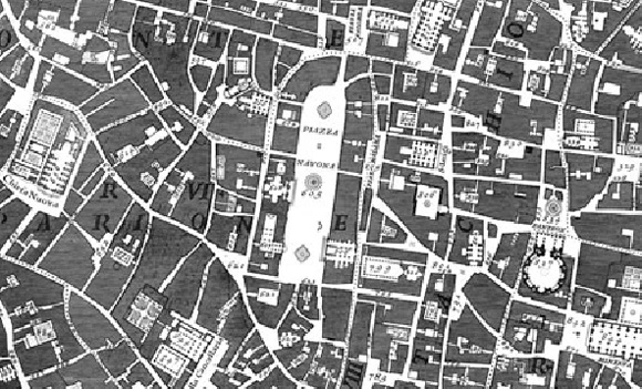
Image taken from the Nolli Map Engine 1.0 by James Tice and Eric Steiner
You guessed it, this is the ultimate claim of objectivity implemented in the plan. However, usually it is claimed o be in use only for visualisation and communication purposes. Nevertheless it also contains the implementation of truth and the establishment of power through the plan.
Bill Hillier describes space in his book ‘Space is the Machine’ 1996 as: “Space is, however, a more inherently difficult topic than physical form, for two reasons. First, space is vacancy rather than thing, so even its bodily nature is not obvious, and cannot be taken for granted in the way that we think we can take objects for granted” (Hillier 1996, p 26). He continues however with “Space is quite simply, what we use in buildings” (Hillier 1996, p 28). And finally he comes up with an astonishing example of a spatial description (and this is the reason it stands in this context to the Nolli plan).
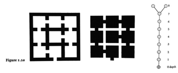
Image by Hillier, taken from Space is the Machine, Fig 1.22 on page 30
For me this image represents two things. For one this is the statement of intent to follow the tradition of the Nolli figure-ground representation as the visualisation for space, and secondly it raises the question of what exists outside the black line. To some extend, I think, the question is answered with the implied assumption that space is taken in a Euclidean sense as a container, a box that you can put things in and arrange them - boxSpace.
In architecture many famous example of the employment of the Nolli Plan can be found. See for example Ado Rossi.
His take on architecture and the representation has largely influenced the Soglio study and the in this context developed representation techniques. The study on alpine architecture in the village of Soglio in Switzerland was conducted by the Institute of Architecture of the University of Applied Science Basel and lead by Michael Alder.
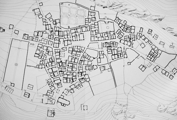
Image taken from ‘Soglio - Siedlungen und Bauten’ - Ground Floor whole settlement
This example takes the idea of figure-ground to the level of the settlement. It completely relies on the rule of accessibility as the guide for spatial representation. In this sense it is what Hillier is talking about in his example. Space is the vacancy between for the human body impenetrable material (I should say object here I guess). In this sense you could probably also call it an accessibility map or a walking guide.
This is then how Hillier introduces the space syntax concept of space description, as a sequence of, for the human body, accessible spaces.
He says: “...related space, almost by definition, cannot be seen all at once, but require movement from one to other to experience the whole” (Hillier 1996, p 26). Interesting here for me is that to some extend this raises some critique on the figure-ground idea of space, as it employees movement ‘to experience the whole’. But more of this in a following post.
As a physical manifestation of this concept here an example I recently came across on A Daily Dose of Architecture. In some sense this is the above space Box concept in built, including the fabrication and installation process.
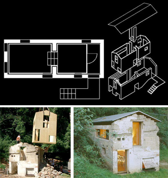
Images by FNP - The project ‘S(ch)austall’ as published by DBZ-online
Alder, M. & Giovanoli, D., 1997. Soglio: Siedlungen und Bauten / Insediamenti e construzioni 2nd ed., Birkhäuser Basel.
Hillier, B., 1996. Space Is the Machine: A Configurational Theory of Architecture, New York: Cambridge University Press.
I would like to start with the widely accepted idea of the figure ground representation of built form. I believe this technique is derived from the Nolli plan of Rome, invented by Giambattista Nolli and published in 1748. In essence it is the representation of physical form in black, leaving the void (space) in between white.
Image taken from the Nolli Map Engine 1.0 by James Tice and Eric Steiner
You guessed it, this is the ultimate claim of objectivity implemented in the plan. However, usually it is claimed o be in use only for visualisation and communication purposes. Nevertheless it also contains the implementation of truth and the establishment of power through the plan.
Bill Hillier describes space in his book ‘Space is the Machine’ 1996 as: “Space is, however, a more inherently difficult topic than physical form, for two reasons. First, space is vacancy rather than thing, so even its bodily nature is not obvious, and cannot be taken for granted in the way that we think we can take objects for granted” (Hillier 1996, p 26). He continues however with “Space is quite simply, what we use in buildings” (Hillier 1996, p 28). And finally he comes up with an astonishing example of a spatial description (and this is the reason it stands in this context to the Nolli plan).
Image by Hillier, taken from Space is the Machine, Fig 1.22 on page 30
For me this image represents two things. For one this is the statement of intent to follow the tradition of the Nolli figure-ground representation as the visualisation for space, and secondly it raises the question of what exists outside the black line. To some extend, I think, the question is answered with the implied assumption that space is taken in a Euclidean sense as a container, a box that you can put things in and arrange them - boxSpace.
In architecture many famous example of the employment of the Nolli Plan can be found. See for example Ado Rossi.
His take on architecture and the representation has largely influenced the Soglio study and the in this context developed representation techniques. The study on alpine architecture in the village of Soglio in Switzerland was conducted by the Institute of Architecture of the University of Applied Science Basel and lead by Michael Alder.
Image taken from ‘Soglio - Siedlungen und Bauten’ - Ground Floor whole settlement
This example takes the idea of figure-ground to the level of the settlement. It completely relies on the rule of accessibility as the guide for spatial representation. In this sense it is what Hillier is talking about in his example. Space is the vacancy between for the human body impenetrable material (I should say object here I guess). In this sense you could probably also call it an accessibility map or a walking guide.
This is then how Hillier introduces the space syntax concept of space description, as a sequence of, for the human body, accessible spaces.
He says: “...related space, almost by definition, cannot be seen all at once, but require movement from one to other to experience the whole” (Hillier 1996, p 26). Interesting here for me is that to some extend this raises some critique on the figure-ground idea of space, as it employees movement ‘to experience the whole’. But more of this in a following post.
As a physical manifestation of this concept here an example I recently came across on A Daily Dose of Architecture. In some sense this is the above space Box concept in built, including the fabrication and installation process.
Images by FNP - The project ‘S(ch)austall’ as published by DBZ-online
Alder, M. & Giovanoli, D., 1997. Soglio: Siedlungen und Bauten / Insediamenti e construzioni 2nd ed., Birkhäuser Basel.
Hillier, B., 1996. Space Is the Machine: A Configurational Theory of Architecture, New York: Cambridge University Press.
Langganan:
Postingan (Atom)