Boundaries do change in shape and ownership. Usually lager pieces, such as plots of land, if they are not public, are traded as a good on the market, payed for and sealed with a contract. So pretty save stuff here.
This is however only a condition and depends on the accepted practice.
In a brand new 010 publication by Malkit Shoshan exactly these conditions and practices are examined. Shoshan meticulous works his way through the spatial extends and manifestations of the Israel-Palestine conflict over the past 100 years. The book 'Atlas of the Conflict - Israel-Palestine' maps out the processed and mechanisms behind the shaping of the area over the past century.

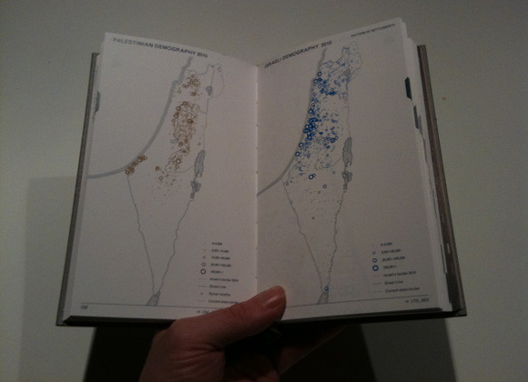
Image taken from Atlas of the Conflict 010 Publishers / Spread 132-133, chapter 3, showing the pattern of settlements by size.
The conflict is a constant topic in the western news with its ebbs and flows. Sometimes the coverage is more intense and then it fades away again, depending mainly on the involvement of western authorities or individuals. The last wave of prolonged news coverage flicked across our screens this past May 31, as the ship convoy, the Gaza Freedom Flotilla, tried to reach the Gaza Strip to deliver humanitarian aid and suplies. Over 700 People from 37 different countries were aboard to support the mision, including Britons. The Israeli special force Shayetet 13 brutally stopped the convoy, killed nine of the passengers and injured dozens. The goods did not reach the destination. This act was widely criticized and dominated the news for a couple of day and it faded away again.
However the extend and the implications of this conflict are hard to grasp by following these only doted coverages. The news stories are usually quite narrated and in comparison to this the Atlas of the Conflict ha a very different approach. It is promising to develop an objective overview through mapping and factual documentation. Factual we can most likely expect from the large news channels, but the comprehensive mapping really offers a new perspective on this entangled situation.
This book is not the first attempt to map out this topic. For example there is the 'The Routledge atlas of the Arab-Israeli conflict' and other earlier book dating back to the eighties or early nineties. In this sense it is time for a new publication with a fresh approach.

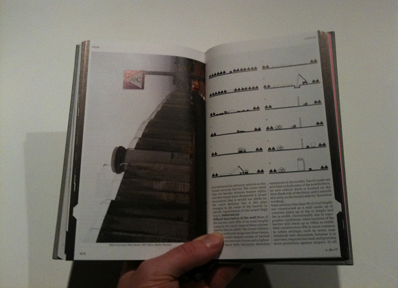
Image taken from Atlas of the Conflict 010 Publishers / Spread 414-415, lexicon, showing the evolution of the wall erected by Israel along the border to Palestine.
The collection of maps is extensive. The book boosts a massive 500 maps and illustrations, detailing different aspects. It puts things into places, context and more importantly into relation to each other. The developed context is however very limited, it hardly goes beyond the ever changing borderlines of the Israeli state. It does however go into a lot of detail on the inside of the border line and puts things on the maps such as infrastructures and demographics.
The publication is organised into two parts. The first part is mapping, mapping, mapping, putting the information into beautifully simplified maps, often reduced to icons. In the second part the author presents a lexicon of selected objects, topics, facts and figures to intensify and narrate the topics presented in the maps section. The two sections are interlinked with page numbers to offer option for nonlinear reading of the atlas. This element however works only one way, from the maps section to the lexicon section.
As hinted above the design of this publication are outstanding and do set standards. There is no other way to put it. Behind this is again Joost Grootens who was already responsible for the design of 'Atlas of the New Dutch Water Defense Line', reviewed here earlier. Through out the book the design works with a three colour colour scheme. Blue is used for Israeli information, brown for Palestine information and black for general info. The illustrations are very often reduced in detail and information to be mainly an icon. This is extremely beautiful and makes this publication a pleasure to brows. However it also struggles at times with the odd non fitting design problem, but thats part of the game.
The overall size of the publication is at first surprising. For an atlas it is very small and more a sort of pocket atlas. This especially in comparison to the oversize 'Atlas o the New Dutch Water Defence Line'.
A striking speciality of the publication's approach to document the conflict over the last 100 years is the largely absent topic of religion and individual destiny. Shoshan explains in the introduction how she started investigating the spatiality of the conflict and it can be assumed that it is a very conscious decision to exclude these topics in order to enable a different access to the conflict as a whole.
While reading through the publication and studying the maps, a very strong sense of temporality of space, land and even country started to emerge. Even though the maps and illustrations are very static and by definition exclude temporality, a story of the conflict started to emerge of which spatial practice of an idea was the key player. All of a sudden it became clear that a country, the land and the people are not one and the same thing. But all have their own very different theoretical interpretation and reading, but also practice.
The practices and strategies employed in this conflict appear in this presentation as tools and mechanics of an extremely theoretical vison of a myth to try and bring the three element of country, land and people together.

Image taken from Atlas of the Conflict 010 Publishers / Spread 154-155, chapter 4, showing two typologies of Israeli spatial practice, the 'Wall and Tower and the 'Moshava'. Both are two ways of settling to claim ownership of the land.
Through out, but foremost in my favorite section, chapter 4, the utilisation and manipulation of the population through spatial planning and strategies is portrayed in depth. Chapter 4 introduces the typologies of settlements on an almost architectural scale and illustrate how individuals are misused for a bigger cause, as pins on a map, as shields, as metaphor, as demonstration, but not as humans.
As a technique of spatiality this illustrates how important or more so fundamental the presence of human being is, to value the spatial dimension. It could be argued that this publication, not intentionally, but as a by product, shows how important the individual act of creation, space making is, as recognised and institutionalised by the Israeli government.
The list of examples and fascinating details that could be put forward here is really long. There are so many moments while reading this book where you go ah..., uh..., yes! and things, you have heard from the sporadic news over the years, all of sudden make sense in a wider context. By definition Shoshan excluded the narratives and stories, but cleans and reassembles the base map for the news, tales, fact, information, tales and events we hear elsewhere. The book might not be as objective as it would like to be, but it as objective as possible an this makes this atlas also worthwhile in another context.

Image taken from 010 Publishers / Cover of the atlas of the Conflict - Israel-Palestine.
Shoshan, M., 2010. Atlas of the Conflict - Israel-Palestine, Rotterdam: 010 Publishers.
Tidak ada komentar:
Posting Komentar