Navigation in al Weather conditions is something not only trained survivors do, but citizens on a daily basis do as part of the urban migration taking place day after day. The scene goes like this: poring rain, in a hurry, forgot to look up the route down from the tube station to Polly Street and I guess not toped up the mobile for the free web allowance... Anyway there is this little piece of paper with a printed Google Map of the area on it. Either the design of the map is too much comic or you are holding it the wrong way up, but it takes too long to decipher. By the time you have located the destination, the paper is wet, by the time you decide which route the paper is soaked and ... you will never be able to take it out of your pocket in one piece again. So no checking on the way.
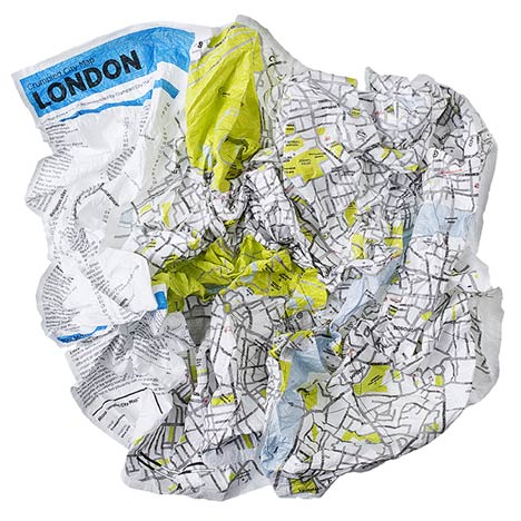
Image taken from Dezeen / The London map all crumbled up.
Interesting how this 'technique' of crumpling the map adds a third dimension to the information and allows for a different perspective, THe flat plane all of a sudden becomes more tangible and a sense of abstraction is present. Through the aspect of irritation of a road all of a sudden going physically uphill the navigation process is more alert and the product placed in a firmer understanding of reduced reality. A benefit of course empowering the user to be freed from the truth of the map via the introduction of possibilities and uncertainty.
The product was presented only last year and go extensively reviewed. The darling of all reviewers it seems. There were articles or mentions from Wire to NYT, or from the TimeOut Lisboa to the Vogue Living.
Image taken from Palomarweb / The New York map all crumbled up.
However, the product also promisses some hidden spots: "Each map proposes 10 “SoulSights”, places that are chosen to excite you. These are places filled with intense emotions that are brought to life by the people passing through or stopping off in them. Visit these places and you will feel like an artist, a poet, a photographer, a director, a lover and a dreamer." This sounds intriguing and might be something different to explore.
So far only the versions are the limit, currently versions are available for: Rome, London, New York, Paris, Berlin. So there are some treasure places missing, but hopefully they are working on extending the coverage. At least there is a hint on the bottom of the website where a Hamburg Map features.
Image taken from Palomarweb / The Hamburg version of the Crumpler City Map.
This week a new guidance system for the 'Quartier des Spectacle' in Montreal was officially unveiled. It is a light projection based signal system to help visitors find their way through the cultural district. As part of its Lighting Plan, the Quartier des spectacles is exploring the possibilities of light for creating signage and expressing identity. A recent pilot project experiments with projecting light onto the pavement to mark the urban landscape. This intervention, realized as part of the Montreal All-Nighter, reinforces the brand image of the cultural heart of the metropolis by bringing together light and graphic design.
The basic idea really to guide pedestrians and after having seen the ultimate promotion clip on the culture district's website one knows why pedestrian guidance might be needed, this is a busy place. There are a lot of events and activity generally happening simultaneously and a efficient and in this case fun tool to support orientation is definitely a great way to go about it. It very much reminds me of the street gaming project last year that was organised in three competing cities in the UK. Coverage HERE. They also used light projections to guide the players. In addition the game also responded and recorded the players performance, guess the interactivity for the Montreal project could be extended beyond the synchronization with the traffic lights. But still a very interesting project that surprises. The project was realized in collaboration with the City of Montreal, particularly the Bureau des festivals et des événements, the Service de police (SPVM) and the City’s traffic experts, Artistic Directors: Ruedi Baur + Jean Beaudoin, Intégral.
Google street view has been introduced back in 2007 and it is already part of everyday navigation. The initial hype ha settled, at least in countries were it is introduced now for more than a year like the UK. In others legal battles and other misunderstandings are still under way. However Google is never short of news stories and with the upcoming Winter Olympics in Vancouver they have taken Street View to the slopes and enable everyone with access to the internet to see the beautiful landscape and ski slopes the athletes will be heading down next week in detail along the tracks. Picked up as reported by the Google Lat Long Blog or Gizmodo. The area covered so far is Vancouver at Whistler Mountain where the Winter Olympics 2010 start on the 12th, which is on Friday.
Image taken from Gogle Slope (Street) View / Vancouver Whistler Mountain
You can test it right here. Put on your skis your already on the slope!
We all use it and without it no one would actually be able to really use the internet. The digital world of linked pages containing information has grown so dramatically that already twelve years ago it became impossible to navigate without navigation aids. Solution had to be found and a new startup firm was leading the way into a future of searching - Google. Over the following years, the management of knowledge became the ultimate service gem. Google rose to transform into the biggest internet company. Of course they don’t only help find internet users find the content they are looking for (or finding at least something), they also are the biggest online advertisement company. This is kind of the ‘making money’ side of the management of knowledge. It is not that you know a lot, but that you can relate the knowledge conveniently to what others might also need.
Image by single-blogs / screenshot showing search results on spezify with the search term single-blogs and playing an single-blogs clip directly form youtube.
However, the search engine interface of the Google website is just one of the search tools. Google provides similar tailored search services for all kind of networks and websites. For example you can click to the right of this text in the third column where it says ‘Custom Search’ and find the content you are looking for directly from the single-blogs blog, all provided by Google. So there are lots of different things searches are good for, but there is one thing I am really getting tired of the bloody list of results. How boring is this? We are all talking about mapping and location based services, networks and clusters, dynamic objects and relationships, responsible environments and individuality, visualisation and graphics, but all we get is a list. Yes, I agree it is the simplest and most plain way of ‘listing’ the results. It seems that Google has even removed the time line graphic I described earlier in another post, which I was really excited about, is now transformed to be a list. I know, there are a lot of issues with all aspects of time and this might not be the best example for not having a list but nevertheless new visualisation methods are needed. Google has made an attempt at changing this at least for image and video content by acquiring/developing coolIris, but here again it is a (nice, interactive) three four row list. Can you imagine how excited I was to come across this new service specify? It is absolute crap and can’t be used for a decent web search, ahh sorry it depends on what you are trying to find, but it comes up with a surprising new concept of showing the result. It displays the content spatially scattered across the screen and you can drag it with your virtual hand and move around on the plain to crawl through the result. Together with the newly announced all body gesture input technique (that actually works - article by the NYTimes) presented this week by Microsoft for its all new gaming platform Natal this could then lead to a real life body experience of virtual search. People would really start wandering off through the results, picking up the results that seem interesting and real-virtually putting them in their pocket, to later pull them out again as the fit with a new blog post for example. The results are all displayed as icons or previews of the content, media content from youtube or vimeo can be played directly from the search result which is nice. It can be called a spatial search experience, since the contend is scattered across the surface. However I am not sure about the organisation of the results spatially and there is definitely room for improvement as the additional dimension adds room for additional criteria. It also operates at the moment a very simple structure that even allow for a address that can be understood e.g. http://www.spezify.com/#/single-blogs - try it out yourself and experience what ‘googling’ the internet could feel like.
If you feel like seeing the tutorial clip on youtube first before trying something so radically new - scared eh? - watch this
Are we losing our Sense of Direction? What a rhetoric question. Without the context this does not really make sense, or does it? Usually as things are starting to be fun, some one comes over to tell you how bad this is and that you should not do it because of this or this or even this reason. At least it was like this when you were a teen, battling for independence with beloved ones. However this is long gone and things have changed since. And still the same situation. But now we are wiser and think twice, maybe it is true, or at least partially, there might be something about this other opinion I have not thought of in this way. Here we re with the news, finally, GPS is BAD! Yes, you are right, your SatNav is doing harm to you as you drive. At least this is what the headlines of the news on the New York Times blog and the walrus magazine suggest Actually it is all based on an article by Alex Hutchinson. We actually have an other SatNav article her on single-blogs, that addresses the problem of arriving at the desired location but in this case it was about spelling the destination name correctly. In general Alex Hutchinson points out in hi article that navigating is a learning process that is a dual relationship between brain and action. The more we use it the better we are at it, but it needs to be maintained. Scientists have identified an area in the brain, the hippocampus, to be responsible or this sort of navigation task. “The brains of London cabbies have outsized rear hippocampuses, because they are required to painstakingly learn the byzantine lanes and byways of the Old World city. (NYblog)” Most of us will not attempt to learn the apparently 25’000 street names and thousands of landmarks required for becoming a cabby. However navigating and orientating do not necessarily require you to know all the names of the streets. Other elements are important in day-to-day navigation. Hutchinson refers to Veronique Bohbot a researcher at McConnell Brain Imaging Center: “Bohbot demonstrated in a widely cited 2003 study that our mapping strategies fall into two basic categories. One is a spatial strategy that involves learning the relationships between various landmarks — creating a cognitive map in your head. The other is a stimulus-response approach that encodes specific routes by memorizing a series of cues, as in: get off the bus when you see the glass skyscraper, then walk toward the big park. For their study, Bohbot created a virtual maze that tested both methods; they found that about half of us prefer spatial strategies, while the other half prefer stimulus-response” (walrus magazine). We probably use both of these techniques depending on the situation, but most likely we prefer one over the other. What navigation type are you?
How do we create mental maps? In a story the New Scientist reports new development in the area of brain studies. The research was presented in nature in September 2009. Over this question scientist have long speculated. The involved brain areas have long been identified, but the how was still subject for debate. Apparently the region in the brain is called hippocampus. The problem so far was that recording the activity required the subject’s head/brain needed to remain fairly stable and this is not possible for normal navigation. The New Scientist reported earlier initial findings related to the brains spatial navigation activities. Reportedly after paying Quake II researchers came up with the idea of using a virtual reality surrounding for the experiment to record brain activity while navigating. Researchers at Princeton University developed a Quake based VR environment for rodents as well as a special navigation ball on which the rodents could run (in a stabilizing harness to keep them relatively still) and navigate the VR maze. Basically they created a mini IMAX for the mouse, reports wired.com. They were the able to scan the mouse’s brain activity as it learned to navigate the maze. Some treats along the way helped I guess. However, there is little information on what they have actually found. At the moment the main interest seems to be the technique how they used to record the brain activity, so mainly the VR for mice set-up. It looks fancy though.
In these experiments scientists are not really interested in how and what the brain records and how participants (in this case mice) actually understand the maze or the environment they have navigated. Here they simply assume that this is taking place. They are talking about a mental map but are just looking at activity as ‘space’ is navigated. To some extend this is only implicit looking at how the memory and sense of place is building up. History is always biased by the fact that it is in the past and it is remembered back from a present state that might be rather different from the past and this influences the way the memory is recalled. Some sort of processing is taking place and the result is a weighted remembering. Through this the history has a present relevance, but is not ‘true’. In this respect the mental map as a review of the maze experience is probably a rather different case than the activity of navigating it. Let’s wait and see how scientist interpret the rodent’s sketch of the maze...
New development on the navigation gadget front. This time it comes from Microsoft and that is in it self a bit surprising. So far the company has not been closely linked with navigation. In general they are trailing behind everyone, generally trying to improve the stuff other have developed and promoted. In this sense this ‘new’ development has to be looked at. The research featured as an article on Technology review this week where its chef researcher Billy Chen introduces us to the concept. They are using video for driving directions. Instead of Google Street View, they are playing video recordings of the route in Microsoft Virtual Earth. The research is partly about the recording and synchronising of the map a video, but partly also about the influence of this method for direction instructions. The results of course claim that the animated instructions enable participants to find the route easier, with 70% to 60% for participants who were instructed only with image (Google images I presume).
Image by Microsoft - (a) Original spacing of panoramas. (b) Final spacing of video frames, after slowing down at landmarks/turns and speeding up between. (c) Straight ahead orientation. (d) Final orientation with look ahead. (e) Widening the view and freezing the landmark thumbnail.
However, the paper written about the project can be found HERE. It has to be noted, that it i not simply a replayed clop. An important feature of the software is the way it focuses on landmark and guides the users view files. It is not a passive record that has just followed the movement. Rather it is a carefully calculated section of the 360 Degree recording. Through this movement emphasis is put on certain aspect along the route, say a landmark. This means that the route somehow has to be processed and interpreted. How quickly and with what kind of system the software can be rolled out is not clear,